Thursday, October 27, 2011
9
Thursday, October 27, 2011
Read more...
Zambezia : New British Possession in Central South Africa
Author: E. A. Maund
Source: Proceedings of the Royal Geographical Society and Monthly Record of Geography,
New Monthly Series, Vol. 12, No. 11 (Nov., 1890), pp. 649-655
Published by: Blackwell Publishing on behalf of The Royal Geographical Society (with the Institute of
British Geographers)
PROCEEDINGS OF 1ST ROYAL GEOGRAPHICAL SOCIETY AND MONTHLY RECORD OF GEOGRAPHY.
A VIGOROUS spirit of commercial enterprise is now busily opening up that rich territory of Zambezia so long traversed by our explorers and ivory hunters, and which only so lately was declared "within the sphere of British influence." The British South Africa Company, empowered by royal charter, will in the immediate future find occupation, homes, and probably riches for thousands of our overteeming population, who are ever eager to colonise, when, as in the present instance, so promising a land is brought within their reach.
Five years ago Sir Charles Warren's expedition opened up the grazing farms of Bechuanaland as a new field for emigration. This has since glown into a thriving crown colony with two fast growing towns, Vryburg and Mafeking, and a railway in construction to traverse it. Matabeleland was then a terra incognita, difficult and dangerous to approach. Ignorance created these illusions, which a more intimate acquaintance has now happily dispelled. The telegraph is fast connecting us with nearly a thousand of our countrymen, gone in to prospect and settle in this once far-off Matabeleland. They are now about Mount Wedsa, at the head of the Sabi river, a locality for years much coveted by trek Boers, as the rich valleys there afford splendid farming opportunities.* There is now an organised post and coach communica-
* Read at the Geographical Section of the British Association for the Advancement of Science, Leeds Meeting, on Sept. 5th last.
* Since the reading of this paper, the above mentioned expeditionary force has arrived at Mount Hampden, lat. 17° 35', long. 31° 22', without let or hindrance from the Matabele. The occupation of Mashonaland is therefore an accomplished fact. Mount Hampden is, we are informed, to be the headquarters of the Company for administrative purposes. The natives have heartily welcomed the white man; and reports from the experts show that the auriferous nature of the country has not been overrated; indeed the richness of the country traversed by this pioneering expedition, both in gold and farm lands, caused many of its members to wish to settle long before reaching the objective point, Mount Hampden, and many prospecting parties from the Transvaal and Cape Colony, are now fast trekking for this New Eldorado.-E. A. M.
* Since the reading of this paper, the above mentioned expeditionary force has arrived at Mount Hampden, lat. 17° 35', long. 31° 22', without let or hindrance from the Matabele. The occupation of Mashonaland is therefore an accomplished fact. Mount Hampden is, we are informed, to be the headquarters of the Company for administrative purposes. The natives have heartily welcomed the white man; and reports from the experts show that the auriferous nature of the country has not been overrated; indeed the richness of the country traversed by this pioneering expedition, both in gold and farm lands, caused many of its members to wish to settle long before reaching the objective point, Mount Hampden, and many prospecting parties from the Transvaal and Cape Colony, are now fast trekking for this New Eldorado.-E. A. M.
tion with Kimberley; and Gu-Bulawayo, the king's chief kraal, is actually within thirty days of London.
I wish to draw the attention to this territory of Zambezia, so quickly being developed, of those who have few opportunities of reading the Royal Geographical Society's reports, and who rarely see our instructive, but too quickly pigeon-holed blue-books.
Of course, many of those forming the Mashonaland pioneering party are fresh to African travelling experiences, and consequently may form and give adverse opinions on the country. It is, however, a splendidly equipped expedition, responsible positions being held by good men, capable of sound judgment men, too, who have been, seen, and think it good enough to go again. For years past, unfortunately, there harre been those who, vhen they got down country, from what used to be the "interior," loved to pose as heroes by accounts of the dangers and difficulties they had gone through, and it was this foolish way of mountainising molehills which retarded many frozn going to see for themselves.
Matabele Land, which lies between 16° and 229 S. lat. and 27° and 33°E . long., is the most promising country for colonisation in South Africa, lying high, generally healthy, rich in minerals and soil, and sparsely populated. The people are not half so black as they are painted (I mean in character). Notwithstanding all their malicious reports to the contrary, the king and people have kept to their promises of friendship to the English, given, when their headmen came to England last year, to see if we were more respectable than the Boers made us out to be.
Lobengula has allowed the construction of a road on to Mount Hampden,a t the sources of the Mazoe river, which, passing the Lundi river at 20½° S. lat., goes on via Mount Wedsa to open up MashonaLand; he even sent his Indunas to greet the expedition now passing through his territory. Of course savages are proverbially fickle, but the chartered company are now in a position, should it ever be to protect their necessary, working parties from the much overrated Matabele hordes.
The country domillated by the Matabele (I cannot say governed) is as big as Germany, and very thinly populated; While the actual territory occupied by them is very small, and would comparea about as does Bavariato the German Empire. They rule from this centre much as the Roman military colonies did in barbarian however, Europe, without, the same civilising influence. Their kraals occupy the plateau forming the watershed between the Zambezi and risers, the Crocodile which varies between four and five thousand feet above sea-level. It is unnecessary to dwell here upon the Matabele nation, whose history has been one of bloodshed since their exodus from Zululand, and who still live under a military despotism of the worst kind. The terror of their assegais reaches beyond the Zambezi, while witchcraft claims many a victim along their own kraals. No better illustration can be given of these horrors than the sinister name of Lobengula's head kraal, Gu-Bulawayo, which means, " The place of killing."
We have now gone among them not as judges, but to change all this killing and slavery by civilising influences; for we should not ourselves forget that, though it may be three-hundred years since we burned bishops and tortured for religion, yet it is actually as late as the eighteenth century that we burned a witch in Perthshire.
It is with reference to the country where the Matabele chief kraals are situated that I would now speak, as during visits in 1885 and 1888, as well as during several lnonths' stay with the king this and last year,I have had the chance of mapping and prospecting this distriet. It will also give some idea of what England is now busily opening up. Witchcraft so terrorises the people that many were the amusing stratagems I had to have recourse to in obtaining angles from the hill-tops. Their confidenee in me, after bringing their Indunas safe home again from their wondrous voyage, was often rudely shaken. " Maundi must be a bit of a tagati (witch) when his sextant brought down the sun," and they were very doubtful whether shooting a kraal with a prismatle compass might not keep the rain off the cornfields in its vicinity. The rains, however, were particularly heavy this year; in the neighbourhood of Bulawayo no less than 40 inches of rain were measured during the months of November, Deeember, January, and February. Like all tropieal rains they are not eontinuous, but eome on in terrifieally heavy thunderstorms, with hot sunshine between. For several weeks before the rains actually fall the clouds bank up and threaten. Then is the king busy with his witch-doctors, making fell potions to eharm the clouds to break. One sees him anxiously gazing at every heavy cloud, for the people come in from all parts to beg rain from him, " their rainmaker," for their parched grounds. And many is the laugh I have had with him on the subject when, after a heavy rain, the people come to "bonga" (praise) him. Great then is his good humour, but he is far too shrewd to be a believer in his own powers in the rain-making line.
The months of September and October, before the rains, are the hottest in the year. All vegetation appears to be burnt up, and the country has a dreary aspect. Cattle grow thin, and the vast herds are sent off low down the rivers to find grass and water. In September I have registered a maximum in the shade ranging between 105° and 111° F.; but the atmosphere is so dry that one does not feel it; 85° near the sea coast, with the air saturated with moisture, being comparatively much hotter. The evenings and tnornings are delightful, and at an elevation of 4000 feet the heat is not enervating, in fact we used to play lawn tennis through it, much to the antlsement of the natives. During the winter months, May, June, and July, it is often very cold at night in these highlands. Even on the Macloutsie river, at elevations under 3000 feet, I have known 15° of frost at night, with the thermometer ranging over 80° in the day, as measured by instruments registered at Kew.Mealies put in soak for the horses over-night have been frozen nearly solid in the morning. Notwithstanding this great variation in temperature, this season is particularly healthy. Trek oxen suffer from the dryness of the grass and cold; so do the poor unclothed natives, who do not thaw out until the sun has well aired the day. The climate is, however, well adapted to the Anglo-Saxon, who can work all the year round in it. There are Englishmen who have lived up there for the last 15 or 20 years. And what is more essential for good colonisation, white children thrive well, some of the missionaries and traders having reared large families. Of course, low down the river banks, during the rainy season, one expects to find fever,as in every new country, but houses built a few hundred feet above the river avoid any such danger.
The Matabele corn-land principally lies in the district embraced by the map accompanying this paper, and when the clouds begin to bank they begin to pick, for as yet the king sets his face against ploughs. Sowing goes on in October and November, and after the first rains it is marvelous the rapidity with which the grass and corn grow. The russet brown country changes suddenly to an emerald green, and the grassland, which is good and abundant, and forests are ablaze with flowers of every hue. Those so soon to have farms up there will assuredly choose this season when wishing to effect a land sale. Harvesting goes on in May and June, and much of the corn is soon turned into Kaffir beer, the national drink, while a good deal is traded for coloured cotton and beads. Kaffir corn was traded last year for five-shillings' worth of goods per sack, but mealies were more difficult to buy. There is a great future in the corn as also in the cattle trade for this country. As I have mentioned, during the winter, or dry season, the cattle are sent off the plateau down the rivers, as higher up the water only remains in pools,the rains being so heavy that they run off quickly into deep channels; but by judicious storage of this rain supply vast tracts might be irrigated, while springs are numerous and only want opening up. In the Gu-Bulawayo district the soil is very deep and rich. Anything and everything seems to grow and flourish. At Shiloh, where Mr Thomas, a missionary, nonv dead, led on water from a spring, and made a large garden, I reaped and thrashed out several sacks of excellent English wheat. I planted potatoes too, which gave a very good crop. Cabbages, carrots, onions, marrows, beans, peas, cucumber,tomatoes, and lettuce also throve well. In fact, all Europeans vegetables, as well as sweet potatoes and mealies, grew very quickly in this irrigated ground. The rivers are generally in beds too deep to run the water off except at great expense; but windmill pumps, nuriyas, and dams could be utilised. With the aid of water, almost any fruit seems to flourish. From the same garden, we enjoyed a large crops of oranges,lemons,figs, grapes, bananas (or rather plantains), peaches, apricots, pomegranates, mulberries,and Cape gooseberries. The date-palms and apple-trees, though growing well, were too young to bear. The orange and lemon trees grow luxuriantly and fruit well. So too do the figs. There were beautiful groves of them in this missionary's garden. The vines grown over high trellised alleys also bore a great deal of lescious fruit. The white ant is the gardeners enemy, but luckily he seems to prefer the sandy soil to the rich loams. Many will be the splendid market gardens by and by to supply the mining centres. The Matabele women are the labourers. One sees during the picking season long rows of girls often with a queen among them, keeping time with their mattocks to a not unmelodious chant. Great quantities of excellent tobacco are grown by the Mashonas and Makalakas, that grown at Inyoka, of which the king receives a yearly tribute, being considered the best. It is principally converted into snuff. The rice grown in Mashona Land is excellent, and cost last year about eighteen shillings' worth of goods par sack. The grass, corn, rice, tobacco, and gardening capabilities of this country are sufficient allurements for farming colonists, while undoubtedly it would produce coffee and sugar. Cotton and india rubber we know it produces in the north, as the Mashonas weave blankets of the former, and make candles of the latter. Indigo grows as a weed, and is used by the Mashonas for dyeing their homemade blankets.
Farmers have to combat lung sickness among cattle and that terrible scourge horse-sickness. Inoculation and quarantine laws will stamp out the former The natives now inoculate for lung-sickness, a treatment which is very successful, but they do not understand closing infected districts. For horse-sickness a specific has still to be found. It comes on yearly after the rains. In good years one per cent perhaps will die, whereas in a bad season like the last one a high percentage succumb. I lost eleven horses out of thirteen in a week. A " salted horse," or one which has gone through the sickness and therefore is supposed to be proof against it, will cost you 50l.o r 60l., whereas a very serviceable horse can be bought for 10l. down country.
Matabele Land is well wooded, though the timber is not large. The mopani, a hard-wood capable of withstanding white ants, is useful for buildng and firewood, while its bark tans excellent leather. Until coal is found nearer than the Zambezi valley there is a good and sufficient supply fbr miIling purposes.
It is to the mineral riches, however, that we must look for the quick development of this country. The gold in MashonaLand will, I believe create a " rush" only to be paralleled in the derelopment of California and the Western States of America. In the accompanying map no less than twenty reefs will be seerl marked, which, as far as the suspicious natives would allow, I prospected. In some of these we found free gold, and colour in the water courses below them. Old workings,too, were visible, which shows that at one time this quartz was worth working, even with crude appliances. There is a banket formation similar to that in the Transsaal in this district. While north of the Ramaquoban river the Charter Prospectors found a large body of reef which returned as much as 2 oz. of gold to the ton. These riches running among and even through the Matabele kraals must for the present lie undeveloped. The rich gold reefs in MashonaLand have been written and talked about for the last twenty years, and below Mount Hampden alluvial deposits are known to exist. This poor man's gold-field the Company has now sent experts to develop. It is from this Mazoe and Hanyani district that the natives bring gold-dust in quills for sale to the white men, notwithstanding the known penalty of death they risk in the traffic. But all this we will hope is now changed. The natives know that the white man will have the gold where it is known to exist, and they have wisely made the best of the situation by putting themselves in the hands of a strong company countenanced by the Great White Queen, who will befriend and not dispossess them.
From numbers of natives who yearly go from here to find work in Johannesburg and Kimberley, the people generally have learned that it is better to have the benefits arising from these mines nearer their own homes. Hence the mass of the working population are in favour of the white man crushing their quartz, and thus saving them 800 miles tramp southwards.
The Makalakas and Mashonas, the original inhabitants of the country, though physically much inferior to their masters, the Matabeles, are clever and willing workers. They fashion the hematite iron, in which mineral the country is particularly rich, into a variety of objects, principally, however, at present into assegais. The copper, too, in the country was formerly smelted by them, as is evidenced by old copper workings I have seen.
Where once the Matabele learn the benefits and freedom to accrue from the white man's rule they will soon, I believe, work as well as the Zulus in Natal. If, however, they will not change the assegais for the pick and the plough, then gradually they will disappear beyond the Zambezi before the inevitable march of civilisation; and from among the downtrodden Mashonas and Makalakas we shall find plenty of labour for both mines and fields.
It is strange that this country, so long reputed to be rich in gold and other minerals, of which Baines wrote twenty years ago as being the Land of Ophir,should until now have baffled our colonising instincts. The work, however, has now begun under the most favourable auspices. The administration of Zambezia is already organised,law and order will reign wherever the Chartered Company penetrate. The revolvers bowie knife, and spirit saloon will there have no place. Gold laws are framed, and the ivory-giver, the elephant, will now be preserved instead of exterminated. Raiding and slavery must cease; and Christianity will spread where hitherto the missionary's labours have been well nigh fruitless.
We English colonise native territories to make them pay. We know that "a strong executive means order," and that stirring up native strife only necessitates costly expeditions. Slavery it is our ambition to abolish. So, too, we suppress the liquor traffic as breeding infinite troubles. Bechuana Land is a happy example of what can be done in this line. Khama's people are rapidly becoming civilised, and afford a good market for our goods. The greed for gold will always overcome climatic difficulties.
5
Matabele and Mashona Lands 1891
Here is another interesting article on the Shona and Ndebele of Zimbabwe life in early 19th century.
Author(s): E. A. MaundSource: Proceedings of the Royal Geographical Society and Monthly Record of Geography,New Monthly Series, Vol. 13, No. 1 (Jan., 1891), pp. 1-21Published by: Blackwell Publishing on behalf of The Royal Geographical Society (with the Institute ofBritish Geographers)
PROCEEDINGS OF THE ROYAL GEOGRAPHICAL SOCIETY AND MONTHLY EECOED OF GEOGRAPHY. On Matabele and Mashona Lands. By E. A. Maund. (Read at the Evening Meeting, November 24th, 1890.) Map, p. 64. Afrioa, with its many fascinations, bas monopolised much of the world's attention in 1890. Enterprise has been stimulated into fresh activity. Pioneers as intrepid as those of the sixteenth century have proved the commercial value of the " interior," which has been little better than a dream for the past three centuries. European Powers have carved up the sunny continent and painted its map with their own colours. A library of information has been compiled, and yet I would still draw your overtaxed attention to a region so long fabled as the seat of an ancient splendour and magnificence: the site from which " They fetched gold four hundred talents to King Solomon," which Milton " thought Ophir," where Moorish tradition supposed Sheba's queen ruled in luxury. The secret of this intensely interesting country, with its numerous pre-historic remains, now bids fair soon to be unlocked. Archaeologists are to have a rare treat in solving the oft-disputed problem as to the origin of these extensive ruins. Though stone-lore may prove this ancient and mythical civilisation to have been Phoenician, yet we know that the mediaeval Monomotapa or Benamatapa, the modern Matabele and Mashona Lands, was an empire rich in gold when Henry VIII. ascended our throne; whose " Great Lord" ruled many kings from his capital Zimbaoch (probably the ruined Zimbabye). Experts may now soon piece up a history by excavation, but at best it will be to show us a sad decadence from an ancient civilisation to a modern savagedom. This glorious country of Zambezia?so long speculated on, now speculated in, so oft traversed by our explorers and hunters, the scene of heart-breaking labours by our missionaries?is now being sys- tematically opened up, not by armed intervention, but by the vigorous epirit of commercial enterprise. With the last decade of this century will begin a new history of civiiisation in this famous forgotten land. The British South Africa Company, empowered by Royal charter, will there find employment, homes and riches for thousands of our over-teeming population, and the place of ruins will again become the support of a mighty empire.
Only five years ago Sir Charles Warren's expedition opened up Bechuana-land as a new field for emigration. This has rapidly grown into a thriving Crown colony, supporting an increasing English and Dutch population, and raising large herds of cattle; thus proving how absolutely unreliable previous reports about this country had been.
It has now two fast-growing towns, Vryburg and Mafeking, and a railway quickly constructing, already complete to Vryburg, which will be the trunk line from Capetown to the northern goldfields, having connections eastward, via Malmani and Johannesburg, with Delagoa Bay and Natal, and westward, via Shoshong, with the rich cattle country of Ngami-land, and passing on via the Victoria Falls to the Barotse, who now ask for our protection.
The telegraph has now passed through and beyond Bechuana-land, linking us with many of our adventurous countrymen already settled in the country dominated by the Matabele, so long deemed dangerous of approach.
Those of us who have been into that desirable country have always looked upon Bechuana-land as only a stepping-stone to the fairer land beyond; and we must remember that it is no further from our present base than was Kimberley from Capetown when the first diamond was found. This unknown " interior " was long erroneously thought to be fever-stricken and uncolonisable, a delusion which better acquaintance has dispelled, and the discovery of vast gold deposits will sooner or later develop a " rush " that will make light of distance, and that no climatic difficulty will deter. The cost of transport for this new northern gold- field, by the southern trunk line with its narrow gauge, would enor- mously reduce the profits. We are soon, however, to tap our new colony from the east coast. Beira, at the mouth of the Pungwe river, the route to which has already been prospected, is scarcely more than 250 miles from the mines, 70 miles of which can be done by water. The rest will not take long to connect up by railway. It is needless to demonstrate the advantages of this route over that to Capetown, which is at least 1800 miles. In America, the railway went first, and the development of the country quickly followed. Let us take a leaf from their book.
The principal physical feature noticeable in Bechuana-land and extending to tbe high veldt plateau of the Matopo range, is a series of vast sand-belts running east and west, varying in breadth from a few thousand yards to 50 miles, and in elevation, the crest above the trough, from a few feet to several hundred. These belts carry good grass and bush with camel-thorn trees, the bush being invariably thickest on the crest, but necessarily lack a surface water-supply. This marked feature extends, with a few accidental variations caused by the outcropping of granite, limestone, and basaltic hills, probably from Namaqua-land and Damara-land on the west to theBasuto Transvaal and Mashona Mountains on the east, and beyond the Zambezi northwards.
The cause of these mysterious sand-belts suggest a problem in physical geography which must be left to geology to decide. They must have been raised in their present wave-like formation either by the aid of water or by a constant and powerful wind. The theory that this part of Africa was an elevated basin, which has gradually drained Zambeziward, is the most acceptable, as in the greatest depression about Lake Ngami and along the fertile valley of the Chobe there is still abundance of water. The continual washing backward and forward of the water has disintegrated the old red sandstone upper crust, and left the red sand in this formation like, on a small scale, the sand-ridges left on our sea-shore by the receding tide; while the kopjes of granite, which all have one form, stand out like rocks at low water.
These kopjes are rocky hills, with the summits apparently denuded, leaving a flat table-top with short cliff-like edge, the debris having fallen in slopes at an angle of 45 degrees, as though crumbled off as the tide fell. Beneath the sand formation is generally to be found a lime? stone sedimentary crust, which in the Kalahari undoubtedly preserves the water underneath from evaporation. Thus at a fountain near Yryburg, between Motito and Takoon, 20 feet beneath the surface there is a running stream 57 feet deep, doing no good to the soil, simply because it wants man, aided by science, to prevent its thus running to waste. The sandstone conglomerates at Kanje and Molopololi, and the banket formation in Matabele-land, were possibly formed by infiltration during this water age. The results of its energetic action is seen in the Matopo range, where you find hills formed of a single block of granite, looking in the distance like our Downs, but on closer inspection this gentle slope is rounded off and polished by the action of the sand- laden water. Detrition has made it as smooth as the shingle-pebbles on our shores. These hills are a favourite haunt of baboons, as immediately they are disturbed they seam per over the steepest and roundest hills, where you cannot follow them. There is apparently no glacial actions, but moulins I have frequently found of all sizes in the smooth surface, often with the rounded boulder in situ. Indeed, for a long time, until I found them large and the boulder there, I had taken them for old Mashona mills, either for crushing corn or quartz, and subsequently I found these people do utilise the smaller for the former purpose. Geologists now by a closer examination will doubtless come across fossils in the limestone crust and sand, which will decide the question as to there having been a large lake since dried up, or one gradually run off, owing to a breach having been made through the

outer rim by some convulsion where the Zambezi now flows out. This lake theory was a favourite speculation of Livingstone.
With regard to the vegetation being thickest on the crest of the belts, I can only suggest that whatever moisture falls, quickly finds its way to the valleys ; consequently the grass grows more luxuriantly there. The grass in these valleys, after good rains, is often 4 to 6 feet high, and, as the natives yearly burn the grass when it is driest, it naturaliy follows that the fire is fiercer in the bottoms than over the crest, where grass is sparse from lack of moisture. Bush and trees perish in the dells, but live through the ordeal above, and often ulti- mately become so thick as to be impenetrable.
It is on the high veldt among the Mashona hills that the rich reefs lie, once so well worth working in pre-historic times, as is evidenced by the old workings to be found all over the country; while the rich watered valleys, from whose streams the natives now wash their quills- full of gold, are capable of raising crops. and feeding cattle for the support of a large European population.
Before going into details I would draw your attention to the map of Matabele-land and Mashona-land. It practically lies between the parallels of 16? and 22? S. lat. and the meridians of 27? to 33? E. long., and is certainly the most promising country for colonisation in South Africa. Compared with the country south of it, Matabele-land is like Canaan after the wilderness. Lying high, generally healthy, and very rich in minerals?gold, copper, and iron having been extensively worked by the ancients with their rude appliances. Its numerous rivers are either run? ning, or have plenty of water in them. The soil is rich and admirably adapted for corn; cattle thrive, and there is an abundance of grass and wood. White children can be reared in the country, which is a sine qua non if it is to be successfully colonised by white men; and, above all, it is sparsely populated.
The country dominated by the Matabele is nearly as large as Germany, while the territory actually occupied by them is very small, and would compare about as Bavaria does to the German Empire. Their kraals occupy the plateau forming the water-parting between the Zam? bezi and the Crocodile rivers. They are a Zulu military organisation, occupying a rich country which they have depopulated, and live under a despotism of the worst kind. The population may be estimated at about 150,000, and has, from the incorporation of conquered elements, become a mixed people of Zulus, Bechuanas, Mashonas, and Makalakas. Their fighting strength is probably not over 14,000 to 15,000 men.
It is unnecessary here to dwell upon the history of the Matabele nation, which has been one of bloodshed since their exodus from Zulu-land under 'Mzilikazi about 1822; it was sixteen years later that they occupied Matabele-land. The terror of their assegais reaches beyond the Zambezi, while witchcraft claims many a victim amongst their kraals. Of their government little can be said, except that everything centres in the King. The secret of his power is on Louis XIV.'s principle, " L'etat, c'est moi." Everything is reported to him, from the death of a calf to the defeat of an impi. Their laws principally relate to witchcraft. One, however, relating to marriage, I am informed, many a married man in England would envy, namely, that mothers-in-law may not enter their son-in-law's house, and, should they meet in the street, they must avert their gaze.
The Matabele, however, have very much improved of late years, and I attribute it to their greater intercourse with white men, through their seeking work at the diamond and gold mines. There has been less raiding, though this will never cease until their organization is destroyed.
King Lo Bengula is by no means so black as he is painted (I mean in character). I must differ from those who say he is " deadly cruel." We must not judge him by our standard. He has to rule a turbulent people, who do not know the value of life. He is shrewd, possesses a wonderful memory, and has sufficient intuitive knowledge to despise many of the superstitions, of which, as rain-maker, he is the chief exponent. Speaking one day to me of killing, he said, " You see, you white men have prisons, and can lock a man up safely. I have not. What am I to do ? When a man would not listen to orders, I used to have his ears cut off as being useless; but whatever their punishment, they frequently repeated the offence. Now I warn them?and then a knobkerried man never repeats his offence." This, for a savage, was fairly logical. It may appear to us cruel; but remember how short a time it is since we hanged for sheep-stealing, and certainly the savage execution with the knobkerrie is not so revolting, and is less painful, than a civilised execution refined with electricity. A blow on the back of the head, and all is over. Lo Bengula is very hospitable to white men, and likes them always about him. He is, in my opinion, much more adapted to a farmer's life?being very fond of his cattle?than to ruling the crew he does. As a young man, he was a keen sportsman, but is now too grossly fat to get on a horse. Though his head kraal has the sinister name of " Gubulawayo," or the " place of killing," yet all that sort of thing has much toned down, and one sees little of such horrors. Lo Bengula is far too refined to ornament the approach to his kraal with human heads, as chiefs do further removed from civilisation. Notwithstanding all the malicious reports to the contrary, the king and people have kept to their promises of friendship to the English, and acted up to their engagements.
I first made Lo Bengula's acquaintance in 1885, when I was sent by Sir Charles Warren with Lieut. Haynes to advise him to keep on friendly terms with Khama, our ally, the chief of the Bechuana. In the next few years, after the craze in South Africa on the discovery of gold at the Randt, poor Lo Bengula was overwhelmed with concession- seekers. When I revisited him at Gubulawayo in 1888 in a private capacity, he sent for me one morning, and after confiding to me his fears of the Boers and Portuguese, and the doubts his people entertained of the power of England after the defeat at Majuba, asked me if I would take a letter from him and accompany two of his head men to England, to see if the White Queen still lived. These envoys, he said, would be " his eyes, ears, and mouth." Though I hesitated at first, I accepted the mission, and next day we started down country?Mr. Colenbrander (the interpreter), two naked old coloured men, that is the envoys, and myself. We gradually dressed the ambassadors on the road. I took them through the Transvaal, partly that they should be able afterwards to compare Boer power with our own, and partly owing to scarcity of water on the other route. By the time we arrived at Capetown, the two envoys apparently became devoted to clothes and delighted with civiiisation. What struck them most at Cape Town was the houses, reared story above story, and the juvenile wax figures in a clothier's window, which they refused to look at, and could not be induced to believe were other than dead children on show before buriaL On the passage to England they were never either sea-sick or home-sick, and enjoyed the voyage in what they called the floating kraal immensely. Soon after landing, through the kind efforts of Lady Frederick Cavendish and Lord Lothian, we went down to Windsor, and they saw the White Queen, who thoroughly won their hearts by her gracious reception. After a month spent in England, during which time they had ample opportunities of seeing England's greatness (for the authorities did all they could to impress them) we returned to the Cape.
On landing, one of these old men (their ages were 65 and 70, or older) showed signs of failing, and I feared I should not get him back to his home. However, in July last year, we arrived safely with the letters and presents in Matabele-land, being received on the frontier with mystic witchcraft rites to impress the nation. For months afterwards long palavers went on, and these old fellows gave the most minute descriptions of all they had seen, and very clever were many of their illustrations. Thus, describing the sea to the Indunas, they said it was like the blue vault of heaven at noon, and the floating kraal was as the sun in the centre ; the water was mostly thus calmly blue, the kraal being pushed through it by its steamer (engine) from behind. The sapient remark of Lo Bengula was, " How could such a vast iron kraal be sustained by tbe water, unless it had supports from the bottom, by which it was pushed along ? Truly these ' Makeeweh ' (white men) are the sons of the sea." Sometimes, the old men added, the sea was " full," i.e., like their boisterous rivers in the rainy season ; then, the floors and roofs of the kraal rocked till the white men danced. This rough sea was soon after passing the Portuguese gate (Lisbon), and refers to a gale in the Bay of Biscay ; but they could not understand how the Queen allowed the Portuguese to have a gate on her water leading to Capetown. London they described as the place all white men must come from; people, people everywhere, all in a hurry, serious of face, and always busy like the white ants. There was not room for every one above ground in this great kraal, for they could see men and horses moving in a stage below, just as they live in houses built one above the other (this referring to Holborn Viaduct). The fire-carriages, too (train), like those between Kimberley and Capetown, have to burrow in the earth under the streets for fear of being stopped by the crowd. The sham fight at Aldershot they described very minutely, and, in my hearing, old Babiaan, turning round to about thirty Indunas, said," Never talk of fighting the white man again. Aough ! They rise up line after line, always firing. Their little boys, the sons of head men, all learn to figbt like men (referring to Eton boys). Their generals corrected all faults; they won't pass a man who is out of time as they dance by in line coming from the fight (the march past)." Many a laugh we had over curious but always intelli? gent descriptions of their recollections. Above all, the interview at Windsor most impressed them, and the sight of Cetewayo's assegais in the corridors of arms there.
They told us they could see that all the kings and queens at Madame Tussaud's were those whom our present Queen had conquered, because last, and downstairs, came Cetewayo?and was not his assegai at the end of the corridor ? This idea we did not think it necessary to correct.
Much more could I tell you of their sayings, but the great result of their visit is what we should appreciate. I have no hesitation in saying that the recent peaceable occupation of Mashona-land by our party of pioneers is the direct outcome of the clever way in which these two old men told their tale, and the King disseminated it among his people.
The Queen did more good for the Empire by that kindly interview at Windsor, than could have been done by thousands of her soldiers. Had the same policy been followed in Zulu-land, how much trouble, how many brave lives, and what vast expenditure, might have been saved ! For the Zulu is our natural ally in South Africa-he admires us for our athletic tastes, manliness, and pluck.
Before I left Matabele-land this year, Lo Bengula had sanctioned the construction of a road by the Chartered Company to Mount Hampden, at the sources of the Mazoe, and had permitted two parties of prospec- tors to work between Bulawayo and Tati, thereby showing his faith in the power of the English, and his determination to act up to his engagements with them.
Let me now state why this country isso well adapted to colonisation. Unfortunately the few Europeans who have lived in what used to be the far " interior," have given us but meagre ideas of its capabilities; and some few, on coming down country, have loved to pose as heroes by accounts of the dangers and difficulties they have gone through. This has undoubtedly retarded the development of what we now know to be so profitable a land, capable of relieving our congested home population, and yielding us the much-needed increase of gold to push forward our commercial enterprises.
The country about to be opened up, for colonisation is, as you see, an extensive plateau, on the water-parting between the Zambezi and the Crocodile rivers. There are no great mountain peaks. To the east the slope of the land is abrupt and the country broken, many of the hills isolated and very conspicuous, while to the north-west it falls in gentle undulations. The plateau is furrowed by many considerable rivers, and their numerous tributaries. The climate in these highlands, which vary from 3000 to 5000 feet above sea-level, is far more healthy than the now well-colonised seaboard of South Africa. The seasons are well marked, and the rainfall good. For eight months, from April to November, the air is particularly dry and salubrious, and compares well with the Free State. During, and just after the rains one must be careful, as in all tropical climates. But with proper precautions dwellings placed high and above exhalations from the marshes left by the subsiding rivers, and above all a judicious abstinence from alcoholic drinks, the new mining and farming communities will be as healthy as are the missionaries who have lived so long there with their families.
Here let me pay a tribute to these silent workers, whose genial hospitality and kindly attention in case of sickness is bestowed on travellers throughout Africa. In Matabele-land as elsewhere they have been the pioneers of civilisation. A heartbreaking up-hill work has theirs been for the past thirty years among the truculent Matabele, and though their converts are few, their example is beneficial to whites and blacks alike. They have built comfortable brick houses, laid on water from brooks and springs, and irrigated gardens which show the capabilities of the soil. The King, it is true, is the only one at present who dares copy them; he has a large commodious brick house put up by their builder, he has too an irrigated garden after their pattern. Now, let us hope, their harvest will come, for with the advent of a white population the old order of things will quickly change in Matabele-land. The example of their health will also be an incentive to our countrymen to house themselves as quickly as possible, or we shall have direful stories of fever, simply resulting from a lack of those com- forts to which they have been used, and which up here will be a necessity.
During the last rainy season in the months of November, December, January and February, the rainfall in the neighbourhood of Buluwayo amounted to upwards of forty inches. Like all tropical rains they are not continuous, but come in terrifically heavy thunderstorms with hot sunshine between. At this time the King is very busy with his witch- doctors, rain-making; often painted with medicine charms in bands like a tiger, or making a dreadful concoction called by the traders " hell broth," to please his credulous people, who come to beg rain for their gardens.
The months of September and October, before the rains, are the hottest in the year. All vegetation appears dried up, and the grass lands are burned off by the natives. Cattle grow thin, and are sent off low down the rivers to find grass and water. The natives have, of course, no knowledge of how to store their generous rainfall. In September I have registered a maximum in the shade ranging between 105? and 111? F., but the atmosphere is so dry that it is more easily supported than 85? near the sea coast, where the air is saturated with moisture. The evenings and mornings are delightful, and on this high ground the heat is never enervating. During the winter months, May, June, and July, it is very cold at night in these highlands. Even on the Macloutsie river, at an elevation of 2500 feet, I have registered 15? of frost at night, with the thermometer ranging up to 80? in the day (observed with instruments registered at Kew). Mealies?that is, Indian corn?put in soak for the horses over night, have been frozen hard in the morning.
Notwithstanding this great variation in temperature, the dry season is particularly healthy. What, however, braces the white man withers up the unclothed native. Trek oxen suffer too from this cold, and the dryness of the grass. By these remarks I wish to convey the fact that with ordinary care this country is admirably adapted to colonisation by us Anglo-Saxons. Englishmen have lived up there for the last twenty-five years, and, what is more essential, traders and missionaries have reared large families. There is not the necessity for sending them home as with Indian children. Neither need men, as on the west coast, return home periodically, in order to recruit. Here they may make a permanent home.
The soil all along the rich valleys is very fertile, and large crops of mealies and Kaffir corn, pumpkins, sweet potatoes, tobacco, and even potatoes and tomatoes are grown by the natives, the two latter by the Makalakas. Sowing goes on in October and November, and after the first rains it is marvellous to note the rapidity with which the grass and corn grow. The country changes its russet-burnt garb as if by magic to one of emerald green, and grass land and forest are ablaze with flowers. Harvest time is in May and June, and much of the corn is soon turned into Kaffir beer?the national drink. There is a great future in the corn, as also in the cattle trade, for this country. Kaffir corn was traded last year for 5s. worth of goods per sack. As before stated, the rains are so heavy that they run off quickly into the lower reaches of the rivers, and in beds too deep to lead off the water, except at great expense; but by judicious storage of this rain supply, vast tracts might be irrigated. Springs are numerous, and only want opening up.
As an illustration of what can be done with this deep alluvial soil, I will instance a garden at Shiloh where Mr. Thomas, a missionary, now dead, led on the water from a spring. From it last year I reaped and threshed several sacks of English wheat, and got a very good crop of potatoes. Cabbages, carrots, onions, marrows, beans, peas, cucumbers, tomatoes, and lettuce also throve well. In fact, all English vegetables, as well as sweet potatoes and mealies, grew very quickly in this irrigated ground. Almost any fruit seems to flourish. From the same garden we enjoyed large crops of oranges, lemons, figs, bananas (or rather plantains), peaches, apricots, pomegranates, mulberries, and Cape goose- berries. The date palm and apple trees, though growing well, were too young to bear. The orange, lemon, and fig trees grow luxuriantly, and fruit well. There were beautiful groves of them in this missionary's garden. The vines, grown over trellised alleys, bore a great many and very heavy bunches of luscious grapes. The white ant is the gardener's enemy, but, luckily, he seems to prefer the sandy soils to the rich loams.
Great quantities of excellent tobacco are grown by the Mashonas and Makalakas, that coming as tribute from Inyoka being considered the best. It is principally converted into snuff. I bring for exhibition some which I brought home last year, together with Mashona pipes. The outside glaze is nicotine squeezed out in preparing the cones. It is very strong, but, faute de mieux, is not bad smoking; we, however, used to wash it in two waters and carefully dry it before smoking Lo Bengula smokes huge pipes of it all day long. The rice grown in Mashona? land is excellent, and cost last year about ISs. worth of goods per sack, while in Mashona-land it is now less than 12s. a bag, i. e. 230 lbs. We used to buy it from the natives in small bags like this, made out of bark; unfortunately, weevils have got into this sample. Cotton and indiarubber we know grow in the north, for the Mashonas weave blankets of the former and make candles of the latter. Indigo grows as a weed, and is used by the natives for dyeing purposes. The grass, corn, rice, tobacco, and gardening capabilities of this country are sufficient allurements for farming colonists, while undoubtedly it would produce cotton, sugar, and coffee.
Three scourges farmers have to combat: lung-sickness among cattle, horse-sickness, and the tsetse fly. The first is successfully treated by inoculation. Natives of course do not understand closing infected districts; but under the white man's laws this disease will undoubtedly be stamped out. For horse-sickness a specific has still to be found, and in the presence of the loss to South Africa arising from it, it would assuredly pay to enlist the services of European scientists. The tsetse fly, whose bite is so deadly to domestic cattle, will disappear with the game. The Transvaal, since the game has been so shot out, is now nearly free from this pest. The Mashonas dry and pound the fly, and give it to their dogs, a fly a day, as a safeguard against the effects of it.
Matabele-land is well wooded, though the timber is not large except along the rivers. The mopani, of which there are vast forests, is a hard wood, capable of withstanding white ants, and is useful for building and firewood, wbile its bark tans excellent leather. I have brought for the inspection of the meeting the skin of a koodoo and pieces of buffalo hide, tanned with it by a native. It is an excellent leather for veldt schoens, as the Boers'understandings are called. Until coal is found nearer than the Zambezi valley, there is a good and sufficient wood supply.
It is to the mineral riches, however, that we must look for the quick development of this country. The gold in Mashonaland, will, I believe, create a rush, only to be paralleled in the development of California and the western states of America. During the seven months I remained with the King after the return of his Indunas, I mapped, and as far as possible prospected, the immediate neighbourhood of his chief kraals. In some of the numerous reefs we found free gold, and old workings were frequently visible. There is, too, in this district a banket formation similar to that in the Transvaal; while north of the Bamaquoban river the Charter prospectors found a body of reef running as much as two ounces to the ton. It is not in this district, however, the Company has begun work ; but it is the Mazoe and Hanyani fields which are being carefully explored by a well-organized pioneering expedition. These northern gold-fields have been talked about for twenty years. From these rivers it is that the natives bring gold-dust in quills for sale to the white men. Mount Hampden tberefore was made the first objective point of the Company. The King sanctioned the making of a road, which is [now open to traffic; while from Fort Salisbury, six miles south of that mountain, the administration of Zambezia has begun, and a township is springing up. The journey thither, under the able command of Col. Pennefather and Sir John Willoughby, gives us some new geographical facts, which I am able to communicate to you to-night. It is far more satisfactory to be able to fill in a map with known physical features than simply to paint it with a proprietary colour.
Passing out of Khama's country, the British South Africa Company's expedition found a fair agricultural country, rising only 500 feet in the 150 miles between the Tuli and Lundi. The former river is 400 yards wide at the drift. Half a dozen new rivers, whose euphonious names I need not trouble you with, are reported as running south-east to the Crocodile. At first the road led through a bush and mopani feldt, while the latter 90 miles consists of grazing flats interspersed with granite and sandstone kopjes. It is sparsely populated by Makalakas and jjanyai who are tributary to LoBengula.
After the Lundi, the elevation gets sharper and the country more difficult; there is a rise of 1500 feet in less than 65 miles to the top of the Providential Pass, the only apparent pass (and that 8 miles long) leading from the low to the high veldt. At the Inkwe (? Tokwe) the height above sea-level is 2700 feet. This is a rapid river with water 50 yards wide and 3 feet deep, even in the dry season. The formation here changes from granite to slate, and the gold indications are very good. We are now among the ancient workings of Benamatapa, Monomotapa, or Quitave. Twelve miles east in the mountains are the grand ruins of its ancient capital, Zimbabye, or Zimbaoe. The many and vast remains of ancient buildings all point, from their propinquity to old workings, to an extensive gold industry, when the means of extraction were crude as compared with modern appliances. The country gra? dually rises into an undulating plateau ranging from 4500 to 5100 feet above sea-level, with park-like scenery, the eastern edge breaking away into rocky gorges, supply ing many tributaries to the Sabi. The water? parting between this river and the Zambezi's tributaries is often very narrow, 100 yards would sometimes only separate the streams running to the two basins. There are apparently no inhabitants on this plateau south of the Hanyani, so cruelly have Matabele assegais done their work.
The bush is thick and the land boggy at the head waters of these rivers, but beyond the Umfuli there are plains from which Mount Hampden rises, stretching away to the head waters of the Mazoe. The neighbourhood of Fort Salisbury is well wooded, and the petty tribal chiefs welcomed the English force, as promising them security. Prospectors are reporting favourably from all directions, and find old workings wherever they go.
There will be no lack of labour, for numbers of natives, who yearly go south to work will gladly save themselves the 800 miles' tramp, and work in the mines nearer home. The Makalakas and Mashonas, the earlier inhabitants of the country, though physically much inferior to their masters, the Matabele, are clever and willing workers. They fashion the iron, in which mineral the country is particularly rich, into a variety of objects, axes, knives, hoes, beads-principally, however, at present into assegais. When once the Matabele learn the benefits and freedom to accrue from the white man's rule, they will soon, I believe, work as well as their kinsmen, the Zulus of Natal. If, however, they will not change the assegai for the pick and the plough, then gradually they will disappear beyond the Zambezi before the inevitable march of civiiisation, and from the down-trodden Mashonas and Makalakas we shall find plenty of labour for both mines and fields.
It is strange that this country, so long fabled as the land of Opbir, and of which Baines and Mauch gave such accurate reports more than twenty years ago, should so long have baffled our colonising instincts.
With regard to these extensive ruins-not only at Zimbabwe, but all over the country- which have so long puzzled the curious from their inaccessibility, the mystery surrounding their origin is now soon to be cleared up by competent archaeologists, who are going out to investigate them. There can be little doubt that they were built for the smelting, and possibly the protection and storage of gold, copper, and other metals; but by whom ? I hear one competent authority say they are probably, from the style of building, Phoenician, another that they are Persian. Some Portuguese manuscripts and maps attribute them to the Moors, and they are certainly similar in style to old Moorish work in the northern hemisphere. There is, however, a Spanish manuscript account of a voyage to Malabar and the coast of Africa by Barbosa, cousin of Magellan, composed by himself in 1514 (translated and published by the Hakluyt Sooiety) in which he says:?" On entering this country of Sofala there is the country of Benamatapa, which is very large and peopled by Gentiles whom the Moors call Cafers. These are brown men. . . ? They carry swords in scabbards of wood bound with gold or other metals. They are men of war, and some of them are merchants. Leaving Sofala for the interior of the country, fourteen days' journey from it, there is a large town of the Gentiles which is called Zimbaoch, in which the King of Benamatapa frequently dwells, and from there to the city of Benamatapa there are six days'journey, and the road goes from Sofala inland towards the Cape of Good Hope. And in the said Benamatapa, which is a very large town, the King is used to make his longest residence; and it is thence the merchants bring to Sofala the gold which they sell to the Moors, without weighing it, for coloured stuffs and beads of Cambay, which are much used and valued amongst them, and the people of the city of Benamatapa say this gold comes from farther off towards the Cape of Good Hope."
This old evidence conclusively proves that the Portuguese had nothing to do with the erection of these buildings. It shows too that the Moors had not then occupied the country. Why should not these brown Gentiles, with their partial civilisation and splendour, have been a decayed remnant of some old Phoenician State ? Let the experts tell us. As I have said, these ruins are always found near gold workings. The buildings are all similar, though some are more substantial than others. I have carefully examined those at Tati and on the Impakwe river. They are built in the same way, of granite hewn into small blocks, somewhat bigger than a brick, and put together without mortar. In the base of both of these there is the same herring-bone course as at Zimbabye, though nearer the base of the wall. On remov- ing the rubbish inside we came upon what were evidently three large circular roasting floors, some five feet in diameter, formed of a kind of hard burnt fireclay, and slightly concave. There were also remains of slag about. The remains on the Impakwe are similar in construction, and are within fifty yards of the river. It was evidently an octagonal
tower. On the ground was a similar roasting floor, and there is much slag about, though I failed to find any quartz. The place was evidently divided up by party-walls. Mr. George Phillips, who was with Mauch when he discovered Zimbabwe told me this morning, that when he examined this ruin at Impakwe more than twenty years ago, the walls were then much higher; but it is a regular outspanning place, and is getting destroyed. On searching it then, he found beneath the debris a fire-clay pipe, about 18 inches long, with a thin bar of much oxidised copper in it.
Zimbabwe was discovered by Mauch in 1871. The ruins then were about 30 feet high, and the walls from 10 feet thick at the base to 7 feet on the summit. There were, too, stone beams projecting 10 feet from the wall, which were ornamented with a pattern of lozenge-shaped figures, separated by horizontal zigzag lines. You have recently read accounts of their great extent, and in the photographic slide I now show you see the walls with the herring-bone course near the summit. The ruins on the Lundi river may be those of Benamatapa, spoken of by Barbosa.
The description of these ruins given by Mauch, and now confirmed by the Charter's pioneers, agrees in many particulars with those given to the English public in Shakespeare's day. Purchas, in his ' Pilgrimage/ printed in London 1614, describing Benamotapa, says:?
"But to returne (and who will not returne) to the mines: There are other mines in the provinces of Boro and Quitieni, in which and in the Rivers is found Gold not so pure. The people are carelesse and negligent to get, and the Moores which traded with them, were faine to give wares in trust, with promise by such a time to pay them in Gold, and the people would not guile in their word " Other mines are in Toroa, wherein are those buildings which Barrius attributeth to some forren Prince, and I, for the reasons before alledged, to Salomon. It is a square fortresse of stone; the stones of marueilous greatnesse, without anie signe of morter or other matter to ioyne them. The wall fiue and twentie spannes thicke, the height not holding proportion. Over the gate are letters, which the learned Moores could neyther reade nor know what letters they were. There are other buildings besides of like fashion. The people call them, the Court, for an Officer keepes it for the Benomotapa, and hath charge of some of his women that are there kept. They esteeme them beyond humane power to build, and, therefore, account them the workes of Deuils; and the Moores which saw them said the Portugais Castles were no way to bee compared to them. They are fiue hundred and tenne miles from Sofala, Westward, in one-and-twentie degrees of Southerly Latitude, in all which space is not found one building Ancient or later; the people are rude, and build cottages of Timber."
Heylin, in his ' Cosmography,' published in 1656, gives a similar description, adding, they were "perhaps the work of some of the ^Ethiopian or Abassine Emperours when their power and Empire was at the highest." While Purchas suggests the "hieroglyphics" were "the old Hebrew Letters, which the Phoenicians of olde, and Samaritans to this day observe."
Millar, in his 'System of Geography,' published in 1782, also gives a graphic account of the ruins, and speaks of the characters written over the gate. These, let us hope, our archeologists will soon be able to unearth and decipher, for they would probably be tbe key to a long lost history. For three hundred years, then, we have had very accurate descriptions of these ruins. And so far from the Portuguese having had anything to do with them, we are distinctly told " the Portugals Castles were no way to bee compared to them."
It is also evident that these buildings were connected with the mining of a people whose history we have lost. It is beside the question whether they were the famed mines of King Solomon, or whether the Queen of Sheba reigned here over a mighty and industrious population. Suffice it for us, that we, with our engines and batteries, are about to make this rich country again disgorge the gold which has so long lain hidden around these pre-historic remains. The work has now begun under the most favourable auspices. The administration of Zambezia is already organised. The gold laws just promulgated give the most liberal terms. Confidence will reign wherever the Chartered Company penetrates. The horrors brought about by liquor saloons among a lawless community will there have no place. Baiding and slavery will cease when once we find paid occupation for the native. Chris? tianity will spread, and peace with prosperity will reign over a region where the most inhuman cruelties have been perpetrated for years.* *
Note on the Map -I would call attention to the great difference in longitude shown on the route from the Macloukie river, an affluent of the Limpopo, to Fort Salisbury to the north. According to Selous, the position of Mount Hampden is about 31? 18' E., but according to the route map of the expedition of the British South African Co. (which is made the basis of our map), Fort Salisbury is 31? 2', and being 8? miles to the S.E. of Mount Hampden, would make the latter about 30? 58J', or about 20' to the west of Selous' position. A curious confirmation of the above westerly alteration is given by Mr. Erskine in his journey to Umzila's, 1871-72 (E.G.S. 'Journal,' vol. xiv.), in dis- cussing the position of Zimbabye (the hill with the celebrated ruins). He says, on p. 45;?" Mr. Mauch's researches place these ruins within 42 miles of my calculated position when at Umzila's kraal, which was determined by several celestial observations by the stars and sun, to be in lat. 20? 23' S. and long. 32? 30' E. by dead reckoning ; about 25 miles to the east of the Sabi river. I neither heard anything of the ruins after repeated inquiries, nor of Mr. Mauch himself. I am therefore surprised to read in his account that he supposed himself only six days' walk from Sofala; whereas the natives informed me that I was at least eight days' walk distant from Sofala, Mr. Mauch being still to the westward of my position by his own account, i.e. west of the Sabi." On p. 46, Mr. Erskine continues:?" It is my opinion that Zimbabye is placed by Mr. Mauch at least 30 or 40 miles too far to the east; and that instead of being 164 miles from Sofala, it is distant about 200 nautical miles, as stated by the old geographers." Now the officers of the expedition place Zimbabye in 31? 6' E., while on Mr. Erskine's map it is given as 31? 40', a difference of 34 minutes, which is fairly approximate to the above-mentioned opinion of Mr. Erskine, viz. 30 or 40miles too far to the east;" and though none of these positions are strictly accurate, yet Mr. Erskine's remarks strikingly confirm the observations of the expedition. Neither Mr. Mauch nor Mr. Selous took any observations for longitude, I believe-[William Shawe, compiler of the map.]
Before the paper,
The Peesident said: In introducing to you Mr. Maund, the reader of the paper to which we are about to listen, I may mention that he was on the staff of Sir Charles Warren in 1885, and by Sir Charles Warren he was sent, with Lieut. Haynes, e.e., to the kraal of Lobengula for the purpose of conferring with that chief and getting him to respect the British protectorate over the chief Khama. In that object he entirely succeeded and obtained eventually great and deserved influence over the mind of Lobengula. From South Africa Mr. Maund transferred himself to North Africa, and there remained for two years. He returned from North Africa and went again into Lobengula's country. By that time, partly in consequence of the reports of Mr. Maund and his colleague, which were published in a Blue-book, there had been a rush of gold-seekers to Lobengula's country, and when Mr. Maund returned he found Lobengula not a little troubled by the many persons who wanted to get concessions out of him. Lobengula then had the happy idea of proposing to Mr. Maund that he should take charge of two of his principal chiefs, take them to England, and present them to the Queen. After some hesitation Mr. Maund accepted this proposal, took the chiefs to England, and did present them to the Queen. They returned and spread in their own country good reports of all that they had seen, and one result of Mr. Maund's efforts, and of those of his companion, has been that Lobengula has thus far been acting not only with the most perfect good faith, but in the most friendly manner towards the British.
After the paper,
Mr. Theodobe Bent : I am afraid I cannot give you very much information on the small data I have to go upon, because the photographs we have seen to-night do not give us very many architectural features. At the same time, I am sure I can join with everybody in feeling excessively grateful toMr. Maund for introducing to us a new feature in African exploration, i.e. that the archasologist has something to do with the South of Africa; and the photographs we have seen are extremely interestiDg, and if only we can find out the origin of these ruins, I am sure we shall contribute a great addition to arehseological lore. In the first place Mr. Maund has spoken of them as possibly Phoenician. Now of course it is a great temptation to talk of Phoenician ruins when there is anything like gold to be found in connection with them, but from my own personai experience of Phoenician ruins, I cannot say that they bear the slightest resemblance whatsoever. In the first place the earliest Phoenicians always built with large stones, and I have seen in the Persian Gulf mounds of blocks of stone of enormous size; passing on into the Mediterranean basin we there get in the earlier Phoenician remains stones of exceeding magnitude and similar masonry; but the Phcenicians, as they progressed in the arts of civiiisa? tion, invariably adopted the art of the people with whom they carried on their trade: Greek influence, Egyptian influence, Assyrian influence, and Roman influence so exercised themselves upon Phcenician art, that in the end their art was almost indis- tinguishable from that of the races with which they carried on trade. They were like ourselves, imitative, fond of trade, carried on commerce, but do not seem to have had the power of originating any artistic devices. Of course it is a speculation, but if it is the Land of Ophir it would be very nice indeed. I like speculations myself immensely, but I think it is the best thing to look upon them with caution. Nine speculations out of ten are wrong, but for the sake of the tenth it is best always to have speculations, and now that Mr. Maund has suggested one or two, I will bring forward my own speculation with regard to these ruins in Mashonaland. He alluded to the fact that somebody said they were Persian. I believe I am the originator of that idea. In the neighbourhood of Zanzibar, some little time ago, Sir John Kirk found some very interesting ruins, which on comparison turned out to be distinctly of Persian origin. In these buildings he found tiles and fragments of pottery, which correspond exactly with the tiles and pottery which are found in the rains of Eai and other Persian towns of the Sassanian dynasty in the neighbourhood of Teheran. Of course it is very curious, at any rate, to track the Persians to Africa at all. It seems a very long way to go for your origin, but if you have them in Africa, there is no reason why you should not bring them into Mashonaland ; but now before doing this it is necessary to turn to the pages of Persian history. The Sassanian dynasty came to its greatest zenith at the time of Kosroes II., usually called the Conqueror. This man carried his armies all through the then known world. He brought terror into the hearts of the Koman emperors in Byzantium. He turned, as we have it distinctly stated, the Eomans out of Arabia and Africa. Furthermore he collected an enormous amount of wealth. His empire was quite the largest the Persians ever had, therefore I think it is not going too far to say that the ruins in Africa, at Zanzibar and the neighbourhood, were probably of the time of the dynasty to which Kosroes II. belonged, and that Kosroes II. was the founder of a Persian empire in Africa.
We will now pass on to consider the photographs that Mr. Maund has placed before us this evening. Architecturally the only point that we could easily dis? tinguish was that geometrical pattern, the course of zigzag round the fort; I have examined one or two other photographs, and these also have geometrical patterns in courses, and of two of these I have photographs of my own, which gives you the exact parallel to those at Eai, near Teheran, in the old ruins which were built in the Sassanian dynasty; hence we seem now rather to have got a clue. This is my theory, and I can only give it for what it is worth, but it really does seem to me that we can reduce ourselves to very narrow limits. Almost immediately after the death of Kosroes II. the Persian empire split up. Before the Sassanian dynasty the Persian empire attempted nothing in the way of exploration in Africa; it was entireiy occupied with its own affairs, so that if they are at all Persian, it must be of that dynasty. But of course this theory is open to doubt, and I am perfectly certain that nothing definite will ever be found out about these forts until they are thoroughly dug out and investigated, when perhaps some inscription will be found that will prove that both Mr. Maund and I are quite wrong.
Mr. G. Phillips : I have lived in the country for the last six and twenty years and outlived all the Englishmen who went with me into that district. I consider the paper that Mr. Maund has read this evening perfectly true and accurate; the only thing that I am afraid of is the salubrity of the low part between the Manyami and Umfuli rivers. Next February and March will determine whether Englishmen can live there. Never an Engiishman has lived there yet. A few natives entered in 1868, and are still there, and a few in March 1870, the year Lobengula was made king of the Matabele, and are still thereabouts; but since then people have been careful to come out in November and go in again in April and May. When I was at the ruins in October 1871 I heard there were two white men close to the ruins of Zimbabye in a destitute condition. One of them was Mauch, with an American named Adam Kinders. Mauch told me they had found some ruins like those I had seen. I asked an old man at the ruins when they were built, and he replied they were built when the stones were soft, or so long ago that no one knew anything at all about it. From there to the westward there is a line of these ruins. A few miles distant is another tremendous ruin, with three gateways and walls, I suppose 30 feet thick at the base, and outside are great heaps of ashes, and a few potsherds. One ironwood tree, that wonld take hundreds of years to grow, had risen through the wall and split it. The most perfect ruin of all, however, is north-west of Tati; it is a little larger than this hall; the walls are 12 to 15 feet thick, and it is entered by a^passage so arranged as to be commanded by arches from the interior, and it only adrnits of the passage of one at a time. I came here just to speak, as Mr. Maund had particularly asked me to do so to-night,
The President: We have listened to a very interesting and valuable paper, and I am afraid that as Mr. Maund is still suffering a good deal from the results of his exploration, he has come here at no inconsiderable inconvenience to himself. I shall then, I am sure, take you all with me, if in your name I return to him our snost sincere thanks.
Mr. Maund thanked the meeting for listening so patiently to his paper, and the proceedings terminated.
Read more...
Author(s): E. A. MaundSource: Proceedings of the Royal Geographical Society and Monthly Record of Geography,New Monthly Series, Vol. 13, No. 1 (Jan., 1891), pp. 1-21Published by: Blackwell Publishing on behalf of The Royal Geographical Society (with the Institute ofBritish Geographers)
PROCEEDINGS OF THE ROYAL GEOGRAPHICAL SOCIETY AND MONTHLY EECOED OF GEOGRAPHY. On Matabele and Mashona Lands. By E. A. Maund. (Read at the Evening Meeting, November 24th, 1890.) Map, p. 64. Afrioa, with its many fascinations, bas monopolised much of the world's attention in 1890. Enterprise has been stimulated into fresh activity. Pioneers as intrepid as those of the sixteenth century have proved the commercial value of the " interior," which has been little better than a dream for the past three centuries. European Powers have carved up the sunny continent and painted its map with their own colours. A library of information has been compiled, and yet I would still draw your overtaxed attention to a region so long fabled as the seat of an ancient splendour and magnificence: the site from which " They fetched gold four hundred talents to King Solomon," which Milton " thought Ophir," where Moorish tradition supposed Sheba's queen ruled in luxury. The secret of this intensely interesting country, with its numerous pre-historic remains, now bids fair soon to be unlocked. Archaeologists are to have a rare treat in solving the oft-disputed problem as to the origin of these extensive ruins. Though stone-lore may prove this ancient and mythical civilisation to have been Phoenician, yet we know that the mediaeval Monomotapa or Benamatapa, the modern Matabele and Mashona Lands, was an empire rich in gold when Henry VIII. ascended our throne; whose " Great Lord" ruled many kings from his capital Zimbaoch (probably the ruined Zimbabye). Experts may now soon piece up a history by excavation, but at best it will be to show us a sad decadence from an ancient civilisation to a modern savagedom. This glorious country of Zambezia?so long speculated on, now speculated in, so oft traversed by our explorers and hunters, the scene of heart-breaking labours by our missionaries?is now being sys- tematically opened up, not by armed intervention, but by the vigorous epirit of commercial enterprise. With the last decade of this century will begin a new history of civiiisation in this famous forgotten land. The British South Africa Company, empowered by Royal charter, will there find employment, homes and riches for thousands of our over-teeming population, and the place of ruins will again become the support of a mighty empire.
Only five years ago Sir Charles Warren's expedition opened up Bechuana-land as a new field for emigration. This has rapidly grown into a thriving Crown colony, supporting an increasing English and Dutch population, and raising large herds of cattle; thus proving how absolutely unreliable previous reports about this country had been.
It has now two fast-growing towns, Vryburg and Mafeking, and a railway quickly constructing, already complete to Vryburg, which will be the trunk line from Capetown to the northern goldfields, having connections eastward, via Malmani and Johannesburg, with Delagoa Bay and Natal, and westward, via Shoshong, with the rich cattle country of Ngami-land, and passing on via the Victoria Falls to the Barotse, who now ask for our protection.
The telegraph has now passed through and beyond Bechuana-land, linking us with many of our adventurous countrymen already settled in the country dominated by the Matabele, so long deemed dangerous of approach.
Those of us who have been into that desirable country have always looked upon Bechuana-land as only a stepping-stone to the fairer land beyond; and we must remember that it is no further from our present base than was Kimberley from Capetown when the first diamond was found. This unknown " interior " was long erroneously thought to be fever-stricken and uncolonisable, a delusion which better acquaintance has dispelled, and the discovery of vast gold deposits will sooner or later develop a " rush " that will make light of distance, and that no climatic difficulty will deter. The cost of transport for this new northern gold- field, by the southern trunk line with its narrow gauge, would enor- mously reduce the profits. We are soon, however, to tap our new colony from the east coast. Beira, at the mouth of the Pungwe river, the route to which has already been prospected, is scarcely more than 250 miles from the mines, 70 miles of which can be done by water. The rest will not take long to connect up by railway. It is needless to demonstrate the advantages of this route over that to Capetown, which is at least 1800 miles. In America, the railway went first, and the development of the country quickly followed. Let us take a leaf from their book.
The principal physical feature noticeable in Bechuana-land and extending to tbe high veldt plateau of the Matopo range, is a series of vast sand-belts running east and west, varying in breadth from a few thousand yards to 50 miles, and in elevation, the crest above the trough, from a few feet to several hundred. These belts carry good grass and bush with camel-thorn trees, the bush being invariably thickest on the crest, but necessarily lack a surface water-supply. This marked feature extends, with a few accidental variations caused by the outcropping of granite, limestone, and basaltic hills, probably from Namaqua-land and Damara-land on the west to theBasuto Transvaal and Mashona Mountains on the east, and beyond the Zambezi northwards.
The cause of these mysterious sand-belts suggest a problem in physical geography which must be left to geology to decide. They must have been raised in their present wave-like formation either by the aid of water or by a constant and powerful wind. The theory that this part of Africa was an elevated basin, which has gradually drained Zambeziward, is the most acceptable, as in the greatest depression about Lake Ngami and along the fertile valley of the Chobe there is still abundance of water. The continual washing backward and forward of the water has disintegrated the old red sandstone upper crust, and left the red sand in this formation like, on a small scale, the sand-ridges left on our sea-shore by the receding tide; while the kopjes of granite, which all have one form, stand out like rocks at low water.
These kopjes are rocky hills, with the summits apparently denuded, leaving a flat table-top with short cliff-like edge, the debris having fallen in slopes at an angle of 45 degrees, as though crumbled off as the tide fell. Beneath the sand formation is generally to be found a lime? stone sedimentary crust, which in the Kalahari undoubtedly preserves the water underneath from evaporation. Thus at a fountain near Yryburg, between Motito and Takoon, 20 feet beneath the surface there is a running stream 57 feet deep, doing no good to the soil, simply because it wants man, aided by science, to prevent its thus running to waste. The sandstone conglomerates at Kanje and Molopololi, and the banket formation in Matabele-land, were possibly formed by infiltration during this water age. The results of its energetic action is seen in the Matopo range, where you find hills formed of a single block of granite, looking in the distance like our Downs, but on closer inspection this gentle slope is rounded off and polished by the action of the sand- laden water. Detrition has made it as smooth as the shingle-pebbles on our shores. These hills are a favourite haunt of baboons, as immediately they are disturbed they seam per over the steepest and roundest hills, where you cannot follow them. There is apparently no glacial actions, but moulins I have frequently found of all sizes in the smooth surface, often with the rounded boulder in situ. Indeed, for a long time, until I found them large and the boulder there, I had taken them for old Mashona mills, either for crushing corn or quartz, and subsequently I found these people do utilise the smaller for the former purpose. Geologists now by a closer examination will doubtless come across fossils in the limestone crust and sand, which will decide the question as to there having been a large lake since dried up, or one gradually run off, owing to a breach having been made through the

outer rim by some convulsion where the Zambezi now flows out. This lake theory was a favourite speculation of Livingstone.
With regard to the vegetation being thickest on the crest of the belts, I can only suggest that whatever moisture falls, quickly finds its way to the valleys ; consequently the grass grows more luxuriantly there. The grass in these valleys, after good rains, is often 4 to 6 feet high, and, as the natives yearly burn the grass when it is driest, it naturaliy follows that the fire is fiercer in the bottoms than over the crest, where grass is sparse from lack of moisture. Bush and trees perish in the dells, but live through the ordeal above, and often ulti- mately become so thick as to be impenetrable.
It is on the high veldt among the Mashona hills that the rich reefs lie, once so well worth working in pre-historic times, as is evidenced by the old workings to be found all over the country; while the rich watered valleys, from whose streams the natives now wash their quills- full of gold, are capable of raising crops. and feeding cattle for the support of a large European population.
Before going into details I would draw your attention to the map of Matabele-land and Mashona-land. It practically lies between the parallels of 16? and 22? S. lat. and the meridians of 27? to 33? E. long., and is certainly the most promising country for colonisation in South Africa. Compared with the country south of it, Matabele-land is like Canaan after the wilderness. Lying high, generally healthy, and very rich in minerals?gold, copper, and iron having been extensively worked by the ancients with their rude appliances. Its numerous rivers are either run? ning, or have plenty of water in them. The soil is rich and admirably adapted for corn; cattle thrive, and there is an abundance of grass and wood. White children can be reared in the country, which is a sine qua non if it is to be successfully colonised by white men; and, above all, it is sparsely populated.
The country dominated by the Matabele is nearly as large as Germany, while the territory actually occupied by them is very small, and would compare about as Bavaria does to the German Empire. Their kraals occupy the plateau forming the water-parting between the Zam? bezi and the Crocodile rivers. They are a Zulu military organisation, occupying a rich country which they have depopulated, and live under a despotism of the worst kind. The population may be estimated at about 150,000, and has, from the incorporation of conquered elements, become a mixed people of Zulus, Bechuanas, Mashonas, and Makalakas. Their fighting strength is probably not over 14,000 to 15,000 men.
It is unnecessary here to dwell upon the history of the Matabele nation, which has been one of bloodshed since their exodus from Zulu-land under 'Mzilikazi about 1822; it was sixteen years later that they occupied Matabele-land. The terror of their assegais reaches beyond the Zambezi, while witchcraft claims many a victim amongst their kraals. Of their government little can be said, except that everything centres in the King. The secret of his power is on Louis XIV.'s principle, " L'etat, c'est moi." Everything is reported to him, from the death of a calf to the defeat of an impi. Their laws principally relate to witchcraft. One, however, relating to marriage, I am informed, many a married man in England would envy, namely, that mothers-in-law may not enter their son-in-law's house, and, should they meet in the street, they must avert their gaze.
The Matabele, however, have very much improved of late years, and I attribute it to their greater intercourse with white men, through their seeking work at the diamond and gold mines. There has been less raiding, though this will never cease until their organization is destroyed.
King Lo Bengula is by no means so black as he is painted (I mean in character). I must differ from those who say he is " deadly cruel." We must not judge him by our standard. He has to rule a turbulent people, who do not know the value of life. He is shrewd, possesses a wonderful memory, and has sufficient intuitive knowledge to despise many of the superstitions, of which, as rain-maker, he is the chief exponent. Speaking one day to me of killing, he said, " You see, you white men have prisons, and can lock a man up safely. I have not. What am I to do ? When a man would not listen to orders, I used to have his ears cut off as being useless; but whatever their punishment, they frequently repeated the offence. Now I warn them?and then a knobkerried man never repeats his offence." This, for a savage, was fairly logical. It may appear to us cruel; but remember how short a time it is since we hanged for sheep-stealing, and certainly the savage execution with the knobkerrie is not so revolting, and is less painful, than a civilised execution refined with electricity. A blow on the back of the head, and all is over. Lo Bengula is very hospitable to white men, and likes them always about him. He is, in my opinion, much more adapted to a farmer's life?being very fond of his cattle?than to ruling the crew he does. As a young man, he was a keen sportsman, but is now too grossly fat to get on a horse. Though his head kraal has the sinister name of " Gubulawayo," or the " place of killing," yet all that sort of thing has much toned down, and one sees little of such horrors. Lo Bengula is far too refined to ornament the approach to his kraal with human heads, as chiefs do further removed from civilisation. Notwithstanding all the malicious reports to the contrary, the king and people have kept to their promises of friendship to the English, and acted up to their engagements.
I first made Lo Bengula's acquaintance in 1885, when I was sent by Sir Charles Warren with Lieut. Haynes to advise him to keep on friendly terms with Khama, our ally, the chief of the Bechuana. In the next few years, after the craze in South Africa on the discovery of gold at the Randt, poor Lo Bengula was overwhelmed with concession- seekers. When I revisited him at Gubulawayo in 1888 in a private capacity, he sent for me one morning, and after confiding to me his fears of the Boers and Portuguese, and the doubts his people entertained of the power of England after the defeat at Majuba, asked me if I would take a letter from him and accompany two of his head men to England, to see if the White Queen still lived. These envoys, he said, would be " his eyes, ears, and mouth." Though I hesitated at first, I accepted the mission, and next day we started down country?Mr. Colenbrander (the interpreter), two naked old coloured men, that is the envoys, and myself. We gradually dressed the ambassadors on the road. I took them through the Transvaal, partly that they should be able afterwards to compare Boer power with our own, and partly owing to scarcity of water on the other route. By the time we arrived at Capetown, the two envoys apparently became devoted to clothes and delighted with civiiisation. What struck them most at Cape Town was the houses, reared story above story, and the juvenile wax figures in a clothier's window, which they refused to look at, and could not be induced to believe were other than dead children on show before buriaL On the passage to England they were never either sea-sick or home-sick, and enjoyed the voyage in what they called the floating kraal immensely. Soon after landing, through the kind efforts of Lady Frederick Cavendish and Lord Lothian, we went down to Windsor, and they saw the White Queen, who thoroughly won their hearts by her gracious reception. After a month spent in England, during which time they had ample opportunities of seeing England's greatness (for the authorities did all they could to impress them) we returned to the Cape.
On landing, one of these old men (their ages were 65 and 70, or older) showed signs of failing, and I feared I should not get him back to his home. However, in July last year, we arrived safely with the letters and presents in Matabele-land, being received on the frontier with mystic witchcraft rites to impress the nation. For months afterwards long palavers went on, and these old fellows gave the most minute descriptions of all they had seen, and very clever were many of their illustrations. Thus, describing the sea to the Indunas, they said it was like the blue vault of heaven at noon, and the floating kraal was as the sun in the centre ; the water was mostly thus calmly blue, the kraal being pushed through it by its steamer (engine) from behind. The sapient remark of Lo Bengula was, " How could such a vast iron kraal be sustained by tbe water, unless it had supports from the bottom, by which it was pushed along ? Truly these ' Makeeweh ' (white men) are the sons of the sea." Sometimes, the old men added, the sea was " full," i.e., like their boisterous rivers in the rainy season ; then, the floors and roofs of the kraal rocked till the white men danced. This rough sea was soon after passing the Portuguese gate (Lisbon), and refers to a gale in the Bay of Biscay ; but they could not understand how the Queen allowed the Portuguese to have a gate on her water leading to Capetown. London they described as the place all white men must come from; people, people everywhere, all in a hurry, serious of face, and always busy like the white ants. There was not room for every one above ground in this great kraal, for they could see men and horses moving in a stage below, just as they live in houses built one above the other (this referring to Holborn Viaduct). The fire-carriages, too (train), like those between Kimberley and Capetown, have to burrow in the earth under the streets for fear of being stopped by the crowd. The sham fight at Aldershot they described very minutely, and, in my hearing, old Babiaan, turning round to about thirty Indunas, said," Never talk of fighting the white man again. Aough ! They rise up line after line, always firing. Their little boys, the sons of head men, all learn to figbt like men (referring to Eton boys). Their generals corrected all faults; they won't pass a man who is out of time as they dance by in line coming from the fight (the march past)." Many a laugh we had over curious but always intelli? gent descriptions of their recollections. Above all, the interview at Windsor most impressed them, and the sight of Cetewayo's assegais in the corridors of arms there.
They told us they could see that all the kings and queens at Madame Tussaud's were those whom our present Queen had conquered, because last, and downstairs, came Cetewayo?and was not his assegai at the end of the corridor ? This idea we did not think it necessary to correct.
Much more could I tell you of their sayings, but the great result of their visit is what we should appreciate. I have no hesitation in saying that the recent peaceable occupation of Mashona-land by our party of pioneers is the direct outcome of the clever way in which these two old men told their tale, and the King disseminated it among his people.
The Queen did more good for the Empire by that kindly interview at Windsor, than could have been done by thousands of her soldiers. Had the same policy been followed in Zulu-land, how much trouble, how many brave lives, and what vast expenditure, might have been saved ! For the Zulu is our natural ally in South Africa-he admires us for our athletic tastes, manliness, and pluck.
Before I left Matabele-land this year, Lo Bengula had sanctioned the construction of a road by the Chartered Company to Mount Hampden, at the sources of the Mazoe, and had permitted two parties of prospec- tors to work between Bulawayo and Tati, thereby showing his faith in the power of the English, and his determination to act up to his engagements with them.
Let me now state why this country isso well adapted to colonisation. Unfortunately the few Europeans who have lived in what used to be the far " interior," have given us but meagre ideas of its capabilities; and some few, on coming down country, have loved to pose as heroes by accounts of the dangers and difficulties they have gone through. This has undoubtedly retarded the development of what we now know to be so profitable a land, capable of relieving our congested home population, and yielding us the much-needed increase of gold to push forward our commercial enterprises.
The country about to be opened up, for colonisation is, as you see, an extensive plateau, on the water-parting between the Zambezi and the Crocodile rivers. There are no great mountain peaks. To the east the slope of the land is abrupt and the country broken, many of the hills isolated and very conspicuous, while to the north-west it falls in gentle undulations. The plateau is furrowed by many considerable rivers, and their numerous tributaries. The climate in these highlands, which vary from 3000 to 5000 feet above sea-level, is far more healthy than the now well-colonised seaboard of South Africa. The seasons are well marked, and the rainfall good. For eight months, from April to November, the air is particularly dry and salubrious, and compares well with the Free State. During, and just after the rains one must be careful, as in all tropical climates. But with proper precautions dwellings placed high and above exhalations from the marshes left by the subsiding rivers, and above all a judicious abstinence from alcoholic drinks, the new mining and farming communities will be as healthy as are the missionaries who have lived so long there with their families.
Here let me pay a tribute to these silent workers, whose genial hospitality and kindly attention in case of sickness is bestowed on travellers throughout Africa. In Matabele-land as elsewhere they have been the pioneers of civilisation. A heartbreaking up-hill work has theirs been for the past thirty years among the truculent Matabele, and though their converts are few, their example is beneficial to whites and blacks alike. They have built comfortable brick houses, laid on water from brooks and springs, and irrigated gardens which show the capabilities of the soil. The King, it is true, is the only one at present who dares copy them; he has a large commodious brick house put up by their builder, he has too an irrigated garden after their pattern. Now, let us hope, their harvest will come, for with the advent of a white population the old order of things will quickly change in Matabele-land. The example of their health will also be an incentive to our countrymen to house themselves as quickly as possible, or we shall have direful stories of fever, simply resulting from a lack of those com- forts to which they have been used, and which up here will be a necessity.
During the last rainy season in the months of November, December, January and February, the rainfall in the neighbourhood of Buluwayo amounted to upwards of forty inches. Like all tropical rains they are not continuous, but come in terrifically heavy thunderstorms with hot sunshine between. At this time the King is very busy with his witch- doctors, rain-making; often painted with medicine charms in bands like a tiger, or making a dreadful concoction called by the traders " hell broth," to please his credulous people, who come to beg rain for their gardens.
The months of September and October, before the rains, are the hottest in the year. All vegetation appears dried up, and the grass lands are burned off by the natives. Cattle grow thin, and are sent off low down the rivers to find grass and water. The natives have, of course, no knowledge of how to store their generous rainfall. In September I have registered a maximum in the shade ranging between 105? and 111? F., but the atmosphere is so dry that it is more easily supported than 85? near the sea coast, where the air is saturated with moisture. The evenings and mornings are delightful, and on this high ground the heat is never enervating. During the winter months, May, June, and July, it is very cold at night in these highlands. Even on the Macloutsie river, at an elevation of 2500 feet, I have registered 15? of frost at night, with the thermometer ranging up to 80? in the day (observed with instruments registered at Kew). Mealies?that is, Indian corn?put in soak for the horses over night, have been frozen hard in the morning.
Notwithstanding this great variation in temperature, the dry season is particularly healthy. What, however, braces the white man withers up the unclothed native. Trek oxen suffer too from this cold, and the dryness of the grass. By these remarks I wish to convey the fact that with ordinary care this country is admirably adapted to colonisation by us Anglo-Saxons. Englishmen have lived up there for the last twenty-five years, and, what is more essential, traders and missionaries have reared large families. There is not the necessity for sending them home as with Indian children. Neither need men, as on the west coast, return home periodically, in order to recruit. Here they may make a permanent home.
The soil all along the rich valleys is very fertile, and large crops of mealies and Kaffir corn, pumpkins, sweet potatoes, tobacco, and even potatoes and tomatoes are grown by the natives, the two latter by the Makalakas. Sowing goes on in October and November, and after the first rains it is marvellous to note the rapidity with which the grass and corn grow. The country changes its russet-burnt garb as if by magic to one of emerald green, and grass land and forest are ablaze with flowers. Harvest time is in May and June, and much of the corn is soon turned into Kaffir beer?the national drink. There is a great future in the corn, as also in the cattle trade, for this country. Kaffir corn was traded last year for 5s. worth of goods per sack. As before stated, the rains are so heavy that they run off quickly into the lower reaches of the rivers, and in beds too deep to lead off the water, except at great expense; but by judicious storage of this rain supply, vast tracts might be irrigated. Springs are numerous, and only want opening up.
As an illustration of what can be done with this deep alluvial soil, I will instance a garden at Shiloh where Mr. Thomas, a missionary, now dead, led on the water from a spring. From it last year I reaped and threshed several sacks of English wheat, and got a very good crop of potatoes. Cabbages, carrots, onions, marrows, beans, peas, cucumbers, tomatoes, and lettuce also throve well. In fact, all English vegetables, as well as sweet potatoes and mealies, grew very quickly in this irrigated ground. Almost any fruit seems to flourish. From the same garden we enjoyed large crops of oranges, lemons, figs, bananas (or rather plantains), peaches, apricots, pomegranates, mulberries, and Cape goose- berries. The date palm and apple trees, though growing well, were too young to bear. The orange, lemon, and fig trees grow luxuriantly, and fruit well. There were beautiful groves of them in this missionary's garden. The vines, grown over trellised alleys, bore a great many and very heavy bunches of luscious grapes. The white ant is the gardener's enemy, but, luckily, he seems to prefer the sandy soils to the rich loams.
Great quantities of excellent tobacco are grown by the Mashonas and Makalakas, that coming as tribute from Inyoka being considered the best. It is principally converted into snuff. I bring for exhibition some which I brought home last year, together with Mashona pipes. The outside glaze is nicotine squeezed out in preparing the cones. It is very strong, but, faute de mieux, is not bad smoking; we, however, used to wash it in two waters and carefully dry it before smoking Lo Bengula smokes huge pipes of it all day long. The rice grown in Mashona? land is excellent, and cost last year about ISs. worth of goods per sack, while in Mashona-land it is now less than 12s. a bag, i. e. 230 lbs. We used to buy it from the natives in small bags like this, made out of bark; unfortunately, weevils have got into this sample. Cotton and indiarubber we know grow in the north, for the Mashonas weave blankets of the former and make candles of the latter. Indigo grows as a weed, and is used by the natives for dyeing purposes. The grass, corn, rice, tobacco, and gardening capabilities of this country are sufficient allurements for farming colonists, while undoubtedly it would produce cotton, sugar, and coffee.
Three scourges farmers have to combat: lung-sickness among cattle, horse-sickness, and the tsetse fly. The first is successfully treated by inoculation. Natives of course do not understand closing infected districts; but under the white man's laws this disease will undoubtedly be stamped out. For horse-sickness a specific has still to be found, and in the presence of the loss to South Africa arising from it, it would assuredly pay to enlist the services of European scientists. The tsetse fly, whose bite is so deadly to domestic cattle, will disappear with the game. The Transvaal, since the game has been so shot out, is now nearly free from this pest. The Mashonas dry and pound the fly, and give it to their dogs, a fly a day, as a safeguard against the effects of it.
Matabele-land is well wooded, though the timber is not large except along the rivers. The mopani, of which there are vast forests, is a hard wood, capable of withstanding white ants, and is useful for building and firewood, wbile its bark tans excellent leather. I have brought for the inspection of the meeting the skin of a koodoo and pieces of buffalo hide, tanned with it by a native. It is an excellent leather for veldt schoens, as the Boers'understandings are called. Until coal is found nearer than the Zambezi valley, there is a good and sufficient wood supply.
It is to the mineral riches, however, that we must look for the quick development of this country. The gold in Mashonaland, will, I believe, create a rush, only to be paralleled in the development of California and the western states of America. During the seven months I remained with the King after the return of his Indunas, I mapped, and as far as possible prospected, the immediate neighbourhood of his chief kraals. In some of the numerous reefs we found free gold, and old workings were frequently visible. There is, too, in this district a banket formation similar to that in the Transvaal; while north of the Bamaquoban river the Charter prospectors found a body of reef running as much as two ounces to the ton. It is not in this district, however, the Company has begun work ; but it is the Mazoe and Hanyani fields which are being carefully explored by a well-organized pioneering expedition. These northern gold-fields have been talked about for twenty years. From these rivers it is that the natives bring gold-dust in quills for sale to the white men. Mount Hampden tberefore was made the first objective point of the Company. The King sanctioned the making of a road, which is [now open to traffic; while from Fort Salisbury, six miles south of that mountain, the administration of Zambezia has begun, and a township is springing up. The journey thither, under the able command of Col. Pennefather and Sir John Willoughby, gives us some new geographical facts, which I am able to communicate to you to-night. It is far more satisfactory to be able to fill in a map with known physical features than simply to paint it with a proprietary colour.
Passing out of Khama's country, the British South Africa Company's expedition found a fair agricultural country, rising only 500 feet in the 150 miles between the Tuli and Lundi. The former river is 400 yards wide at the drift. Half a dozen new rivers, whose euphonious names I need not trouble you with, are reported as running south-east to the Crocodile. At first the road led through a bush and mopani feldt, while the latter 90 miles consists of grazing flats interspersed with granite and sandstone kopjes. It is sparsely populated by Makalakas and jjanyai who are tributary to LoBengula.
After the Lundi, the elevation gets sharper and the country more difficult; there is a rise of 1500 feet in less than 65 miles to the top of the Providential Pass, the only apparent pass (and that 8 miles long) leading from the low to the high veldt. At the Inkwe (? Tokwe) the height above sea-level is 2700 feet. This is a rapid river with water 50 yards wide and 3 feet deep, even in the dry season. The formation here changes from granite to slate, and the gold indications are very good. We are now among the ancient workings of Benamatapa, Monomotapa, or Quitave. Twelve miles east in the mountains are the grand ruins of its ancient capital, Zimbabye, or Zimbaoe. The many and vast remains of ancient buildings all point, from their propinquity to old workings, to an extensive gold industry, when the means of extraction were crude as compared with modern appliances. The country gra? dually rises into an undulating plateau ranging from 4500 to 5100 feet above sea-level, with park-like scenery, the eastern edge breaking away into rocky gorges, supply ing many tributaries to the Sabi. The water? parting between this river and the Zambezi's tributaries is often very narrow, 100 yards would sometimes only separate the streams running to the two basins. There are apparently no inhabitants on this plateau south of the Hanyani, so cruelly have Matabele assegais done their work.
The bush is thick and the land boggy at the head waters of these rivers, but beyond the Umfuli there are plains from which Mount Hampden rises, stretching away to the head waters of the Mazoe. The neighbourhood of Fort Salisbury is well wooded, and the petty tribal chiefs welcomed the English force, as promising them security. Prospectors are reporting favourably from all directions, and find old workings wherever they go.
There will be no lack of labour, for numbers of natives, who yearly go south to work will gladly save themselves the 800 miles' tramp, and work in the mines nearer home. The Makalakas and Mashonas, the earlier inhabitants of the country, though physically much inferior to their masters, the Matabele, are clever and willing workers. They fashion the iron, in which mineral the country is particularly rich, into a variety of objects, axes, knives, hoes, beads-principally, however, at present into assegais. When once the Matabele learn the benefits and freedom to accrue from the white man's rule, they will soon, I believe, work as well as their kinsmen, the Zulus of Natal. If, however, they will not change the assegai for the pick and the plough, then gradually they will disappear beyond the Zambezi before the inevitable march of civiiisation, and from the down-trodden Mashonas and Makalakas we shall find plenty of labour for both mines and fields.
It is strange that this country, so long fabled as the land of Opbir, and of which Baines and Mauch gave such accurate reports more than twenty years ago, should so long have baffled our colonising instincts.
With regard to these extensive ruins-not only at Zimbabwe, but all over the country- which have so long puzzled the curious from their inaccessibility, the mystery surrounding their origin is now soon to be cleared up by competent archaeologists, who are going out to investigate them. There can be little doubt that they were built for the smelting, and possibly the protection and storage of gold, copper, and other metals; but by whom ? I hear one competent authority say they are probably, from the style of building, Phoenician, another that they are Persian. Some Portuguese manuscripts and maps attribute them to the Moors, and they are certainly similar in style to old Moorish work in the northern hemisphere. There is, however, a Spanish manuscript account of a voyage to Malabar and the coast of Africa by Barbosa, cousin of Magellan, composed by himself in 1514 (translated and published by the Hakluyt Sooiety) in which he says:?" On entering this country of Sofala there is the country of Benamatapa, which is very large and peopled by Gentiles whom the Moors call Cafers. These are brown men. . . ? They carry swords in scabbards of wood bound with gold or other metals. They are men of war, and some of them are merchants. Leaving Sofala for the interior of the country, fourteen days' journey from it, there is a large town of the Gentiles which is called Zimbaoch, in which the King of Benamatapa frequently dwells, and from there to the city of Benamatapa there are six days'journey, and the road goes from Sofala inland towards the Cape of Good Hope. And in the said Benamatapa, which is a very large town, the King is used to make his longest residence; and it is thence the merchants bring to Sofala the gold which they sell to the Moors, without weighing it, for coloured stuffs and beads of Cambay, which are much used and valued amongst them, and the people of the city of Benamatapa say this gold comes from farther off towards the Cape of Good Hope."
This old evidence conclusively proves that the Portuguese had nothing to do with the erection of these buildings. It shows too that the Moors had not then occupied the country. Why should not these brown Gentiles, with their partial civilisation and splendour, have been a decayed remnant of some old Phoenician State ? Let the experts tell us. As I have said, these ruins are always found near gold workings. The buildings are all similar, though some are more substantial than others. I have carefully examined those at Tati and on the Impakwe river. They are built in the same way, of granite hewn into small blocks, somewhat bigger than a brick, and put together without mortar. In the base of both of these there is the same herring-bone course as at Zimbabye, though nearer the base of the wall. On remov- ing the rubbish inside we came upon what were evidently three large circular roasting floors, some five feet in diameter, formed of a kind of hard burnt fireclay, and slightly concave. There were also remains of slag about. The remains on the Impakwe are similar in construction, and are within fifty yards of the river. It was evidently an octagonal
 |
| Zimbabwe Ruins |
tower. On the ground was a similar roasting floor, and there is much slag about, though I failed to find any quartz. The place was evidently divided up by party-walls. Mr. George Phillips, who was with Mauch when he discovered Zimbabwe told me this morning, that when he examined this ruin at Impakwe more than twenty years ago, the walls were then much higher; but it is a regular outspanning place, and is getting destroyed. On searching it then, he found beneath the debris a fire-clay pipe, about 18 inches long, with a thin bar of much oxidised copper in it.
Zimbabwe was discovered by Mauch in 1871. The ruins then were about 30 feet high, and the walls from 10 feet thick at the base to 7 feet on the summit. There were, too, stone beams projecting 10 feet from the wall, which were ornamented with a pattern of lozenge-shaped figures, separated by horizontal zigzag lines. You have recently read accounts of their great extent, and in the photographic slide I now show you see the walls with the herring-bone course near the summit. The ruins on the Lundi river may be those of Benamatapa, spoken of by Barbosa.
The description of these ruins given by Mauch, and now confirmed by the Charter's pioneers, agrees in many particulars with those given to the English public in Shakespeare's day. Purchas, in his ' Pilgrimage/ printed in London 1614, describing Benamotapa, says:?
"But to returne (and who will not returne) to the mines: There are other mines in the provinces of Boro and Quitieni, in which and in the Rivers is found Gold not so pure. The people are carelesse and negligent to get, and the Moores which traded with them, were faine to give wares in trust, with promise by such a time to pay them in Gold, and the people would not guile in their word " Other mines are in Toroa, wherein are those buildings which Barrius attributeth to some forren Prince, and I, for the reasons before alledged, to Salomon. It is a square fortresse of stone; the stones of marueilous greatnesse, without anie signe of morter or other matter to ioyne them. The wall fiue and twentie spannes thicke, the height not holding proportion. Over the gate are letters, which the learned Moores could neyther reade nor know what letters they were. There are other buildings besides of like fashion. The people call them, the Court, for an Officer keepes it for the Benomotapa, and hath charge of some of his women that are there kept. They esteeme them beyond humane power to build, and, therefore, account them the workes of Deuils; and the Moores which saw them said the Portugais Castles were no way to bee compared to them. They are fiue hundred and tenne miles from Sofala, Westward, in one-and-twentie degrees of Southerly Latitude, in all which space is not found one building Ancient or later; the people are rude, and build cottages of Timber."
Heylin, in his ' Cosmography,' published in 1656, gives a similar description, adding, they were "perhaps the work of some of the ^Ethiopian or Abassine Emperours when their power and Empire was at the highest." While Purchas suggests the "hieroglyphics" were "the old Hebrew Letters, which the Phoenicians of olde, and Samaritans to this day observe."
Millar, in his 'System of Geography,' published in 1782, also gives a graphic account of the ruins, and speaks of the characters written over the gate. These, let us hope, our archeologists will soon be able to unearth and decipher, for they would probably be tbe key to a long lost history. For three hundred years, then, we have had very accurate descriptions of these ruins. And so far from the Portuguese having had anything to do with them, we are distinctly told " the Portugals Castles were no way to bee compared to them."
It is also evident that these buildings were connected with the mining of a people whose history we have lost. It is beside the question whether they were the famed mines of King Solomon, or whether the Queen of Sheba reigned here over a mighty and industrious population. Suffice it for us, that we, with our engines and batteries, are about to make this rich country again disgorge the gold which has so long lain hidden around these pre-historic remains. The work has now begun under the most favourable auspices. The administration of Zambezia is already organised. The gold laws just promulgated give the most liberal terms. Confidence will reign wherever the Chartered Company penetrates. The horrors brought about by liquor saloons among a lawless community will there have no place. Baiding and slavery will cease when once we find paid occupation for the native. Chris? tianity will spread, and peace with prosperity will reign over a region where the most inhuman cruelties have been perpetrated for years.* *
Note on the Map -I would call attention to the great difference in longitude shown on the route from the Macloukie river, an affluent of the Limpopo, to Fort Salisbury to the north. According to Selous, the position of Mount Hampden is about 31? 18' E., but according to the route map of the expedition of the British South African Co. (which is made the basis of our map), Fort Salisbury is 31? 2', and being 8? miles to the S.E. of Mount Hampden, would make the latter about 30? 58J', or about 20' to the west of Selous' position. A curious confirmation of the above westerly alteration is given by Mr. Erskine in his journey to Umzila's, 1871-72 (E.G.S. 'Journal,' vol. xiv.), in dis- cussing the position of Zimbabye (the hill with the celebrated ruins). He says, on p. 45;?" Mr. Mauch's researches place these ruins within 42 miles of my calculated position when at Umzila's kraal, which was determined by several celestial observations by the stars and sun, to be in lat. 20? 23' S. and long. 32? 30' E. by dead reckoning ; about 25 miles to the east of the Sabi river. I neither heard anything of the ruins after repeated inquiries, nor of Mr. Mauch himself. I am therefore surprised to read in his account that he supposed himself only six days' walk from Sofala; whereas the natives informed me that I was at least eight days' walk distant from Sofala, Mr. Mauch being still to the westward of my position by his own account, i.e. west of the Sabi." On p. 46, Mr. Erskine continues:?" It is my opinion that Zimbabye is placed by Mr. Mauch at least 30 or 40 miles too far to the east; and that instead of being 164 miles from Sofala, it is distant about 200 nautical miles, as stated by the old geographers." Now the officers of the expedition place Zimbabye in 31? 6' E., while on Mr. Erskine's map it is given as 31? 40', a difference of 34 minutes, which is fairly approximate to the above-mentioned opinion of Mr. Erskine, viz. 30 or 40miles too far to the east;" and though none of these positions are strictly accurate, yet Mr. Erskine's remarks strikingly confirm the observations of the expedition. Neither Mr. Mauch nor Mr. Selous took any observations for longitude, I believe-[William Shawe, compiler of the map.]
Before the paper,
The Peesident said: In introducing to you Mr. Maund, the reader of the paper to which we are about to listen, I may mention that he was on the staff of Sir Charles Warren in 1885, and by Sir Charles Warren he was sent, with Lieut. Haynes, e.e., to the kraal of Lobengula for the purpose of conferring with that chief and getting him to respect the British protectorate over the chief Khama. In that object he entirely succeeded and obtained eventually great and deserved influence over the mind of Lobengula. From South Africa Mr. Maund transferred himself to North Africa, and there remained for two years. He returned from North Africa and went again into Lobengula's country. By that time, partly in consequence of the reports of Mr. Maund and his colleague, which were published in a Blue-book, there had been a rush of gold-seekers to Lobengula's country, and when Mr. Maund returned he found Lobengula not a little troubled by the many persons who wanted to get concessions out of him. Lobengula then had the happy idea of proposing to Mr. Maund that he should take charge of two of his principal chiefs, take them to England, and present them to the Queen. After some hesitation Mr. Maund accepted this proposal, took the chiefs to England, and did present them to the Queen. They returned and spread in their own country good reports of all that they had seen, and one result of Mr. Maund's efforts, and of those of his companion, has been that Lobengula has thus far been acting not only with the most perfect good faith, but in the most friendly manner towards the British.
After the paper,
Mr. Theodobe Bent : I am afraid I cannot give you very much information on the small data I have to go upon, because the photographs we have seen to-night do not give us very many architectural features. At the same time, I am sure I can join with everybody in feeling excessively grateful toMr. Maund for introducing to us a new feature in African exploration, i.e. that the archasologist has something to do with the South of Africa; and the photographs we have seen are extremely interestiDg, and if only we can find out the origin of these ruins, I am sure we shall contribute a great addition to arehseological lore. In the first place Mr. Maund has spoken of them as possibly Phoenician. Now of course it is a great temptation to talk of Phoenician ruins when there is anything like gold to be found in connection with them, but from my own personai experience of Phoenician ruins, I cannot say that they bear the slightest resemblance whatsoever. In the first place the earliest Phoenicians always built with large stones, and I have seen in the Persian Gulf mounds of blocks of stone of enormous size; passing on into the Mediterranean basin we there get in the earlier Phoenician remains stones of exceeding magnitude and similar masonry; but the Phcenicians, as they progressed in the arts of civiiisa? tion, invariably adopted the art of the people with whom they carried on their trade: Greek influence, Egyptian influence, Assyrian influence, and Roman influence so exercised themselves upon Phcenician art, that in the end their art was almost indis- tinguishable from that of the races with which they carried on trade. They were like ourselves, imitative, fond of trade, carried on commerce, but do not seem to have had the power of originating any artistic devices. Of course it is a speculation, but if it is the Land of Ophir it would be very nice indeed. I like speculations myself immensely, but I think it is the best thing to look upon them with caution. Nine speculations out of ten are wrong, but for the sake of the tenth it is best always to have speculations, and now that Mr. Maund has suggested one or two, I will bring forward my own speculation with regard to these ruins in Mashonaland. He alluded to the fact that somebody said they were Persian. I believe I am the originator of that idea. In the neighbourhood of Zanzibar, some little time ago, Sir John Kirk found some very interesting ruins, which on comparison turned out to be distinctly of Persian origin. In these buildings he found tiles and fragments of pottery, which correspond exactly with the tiles and pottery which are found in the rains of Eai and other Persian towns of the Sassanian dynasty in the neighbourhood of Teheran. Of course it is very curious, at any rate, to track the Persians to Africa at all. It seems a very long way to go for your origin, but if you have them in Africa, there is no reason why you should not bring them into Mashonaland ; but now before doing this it is necessary to turn to the pages of Persian history. The Sassanian dynasty came to its greatest zenith at the time of Kosroes II., usually called the Conqueror. This man carried his armies all through the then known world. He brought terror into the hearts of the Koman emperors in Byzantium. He turned, as we have it distinctly stated, the Eomans out of Arabia and Africa. Furthermore he collected an enormous amount of wealth. His empire was quite the largest the Persians ever had, therefore I think it is not going too far to say that the ruins in Africa, at Zanzibar and the neighbourhood, were probably of the time of the dynasty to which Kosroes II. belonged, and that Kosroes II. was the founder of a Persian empire in Africa.
We will now pass on to consider the photographs that Mr. Maund has placed before us this evening. Architecturally the only point that we could easily dis? tinguish was that geometrical pattern, the course of zigzag round the fort; I have examined one or two other photographs, and these also have geometrical patterns in courses, and of two of these I have photographs of my own, which gives you the exact parallel to those at Eai, near Teheran, in the old ruins which were built in the Sassanian dynasty; hence we seem now rather to have got a clue. This is my theory, and I can only give it for what it is worth, but it really does seem to me that we can reduce ourselves to very narrow limits. Almost immediately after the death of Kosroes II. the Persian empire split up. Before the Sassanian dynasty the Persian empire attempted nothing in the way of exploration in Africa; it was entireiy occupied with its own affairs, so that if they are at all Persian, it must be of that dynasty. But of course this theory is open to doubt, and I am perfectly certain that nothing definite will ever be found out about these forts until they are thoroughly dug out and investigated, when perhaps some inscription will be found that will prove that both Mr. Maund and I are quite wrong.
Mr. G. Phillips : I have lived in the country for the last six and twenty years and outlived all the Englishmen who went with me into that district. I consider the paper that Mr. Maund has read this evening perfectly true and accurate; the only thing that I am afraid of is the salubrity of the low part between the Manyami and Umfuli rivers. Next February and March will determine whether Englishmen can live there. Never an Engiishman has lived there yet. A few natives entered in 1868, and are still there, and a few in March 1870, the year Lobengula was made king of the Matabele, and are still thereabouts; but since then people have been careful to come out in November and go in again in April and May. When I was at the ruins in October 1871 I heard there were two white men close to the ruins of Zimbabye in a destitute condition. One of them was Mauch, with an American named Adam Kinders. Mauch told me they had found some ruins like those I had seen. I asked an old man at the ruins when they were built, and he replied they were built when the stones were soft, or so long ago that no one knew anything at all about it. From there to the westward there is a line of these ruins. A few miles distant is another tremendous ruin, with three gateways and walls, I suppose 30 feet thick at the base, and outside are great heaps of ashes, and a few potsherds. One ironwood tree, that wonld take hundreds of years to grow, had risen through the wall and split it. The most perfect ruin of all, however, is north-west of Tati; it is a little larger than this hall; the walls are 12 to 15 feet thick, and it is entered by a^passage so arranged as to be commanded by arches from the interior, and it only adrnits of the passage of one at a time. I came here just to speak, as Mr. Maund had particularly asked me to do so to-night,
The President: We have listened to a very interesting and valuable paper, and I am afraid that as Mr. Maund is still suffering a good deal from the results of his exploration, he has come here at no inconsiderable inconvenience to himself. I shall then, I am sure, take you all with me, if in your name I return to him our snost sincere thanks.
Mr. Maund thanked the meeting for listening so patiently to his paper, and the proceedings terminated.
Saturday, August 6, 2011
8
Saturday, August 6, 2011
The basic population of the area occupied by the Ndebele in the 1840s spoke the Kalanga dialect of Shona and was descended from the people of the Leopards Kopje culture, who occupied the area from about 1000.4 In the fifteenth century, people of the Zimbabwe culture moved west into the Kalanga country, and some time after 1450 the Torwa dynasty ruled over a state that was a successor to Zimbabwe, based on Khami. Some time between 1644 and 1683 the Torwa dynasty was succeeded by that of the Changamire Rozvi, whose main centres were the stone buildings of Danangombe (Dhlodhlo) and Manyanga (Tabazikamnambo).5 But although the Khami culture was a continuation of that of Zimbabwe,6 the Kalanga remained the basic population, and by the nineteenth century the Rozvi of the Changamire dynasty were speaking a variant of Kalanga.7 The dry environment of the southwestern plateau favoured cattle breeding, and from the earliest days of Kalanga settlement the economy of the area was strongly committed to the build-up of herds. In addition, until the early nineteenth century the goldfields of the area were in production on a reduced scale and the Torwa and Changamire dynasties exported gold and ivory to the Portuguese centres on the Zambezi and the coast in return for cloth and beads, as well as other articles.8
When, in the early nineteenth century, the migrations of Mpanga, Ngwana Maseko, Zwangendaba and Nyamazana, set off by the mfecane, struck the Changamire state, it was poorly prepared to stand the shock. Droughts, wars with the Karanga advancing from the north-east, Tswana raids, strife between the royal dynasty and the Mwari cult and civil wars within the dynasty had seriously affected the strength of a state that had earlier been one of the foremost military powers of southern Africa.9 By the early part of the nineteenth century the most important Rozvi families were grouped in a ring around the Changamire capitals of Danangombe and Manyanga east of the Bembesi river. West of the Bembesi, the Khami area was under a Kalanga sub-ruler, Ndumba.'0 The most serious split within the Changamire dynasty was between the houses of Miutinhima, a son of the Changamire Gumboremvura, and of Chirisamhuru, who was Changamire in the early 1830s.11 The Mutinhima faction occupied the Mulungwane hills and influenced a wide area east of the upper Lundi. Other Rozvi sub-rulers of the main dynasty were Lukuluba of the Ghoko hills, Rozani of the Vungu river, Swabasvi of the Somabula forest, and a ruler praise-named Dlembeu on the Mpopoti range.12 Nevertheless, weakened as it was, the Changamire state withstood the attacks of Mpanga, Ngwana Maseko and Zwangendaba, who were driven off, although they did a great deal of damage, taking grain and cattle. Even the death of Changamire Chirisamhuru at the hands of Nyamazana's group did not destroy the Changamire state.13 It seems likely that no Mambo was installed immediately after Chirisamhuru's death, but at some point well before 1852 his son Tohwechipi succeeded him, and as he received the support of the Mutinhima house he can fairly be said to have been the next Mambo.14
The Ndebele had thus become rivals of the Rozvi as rulers of the Kalanga and other Shona peoples, and in the period when the Changamire dynasty was weakened by the death of Chirisamhuru, Mzilikazi actually took his place as overlord of certain Rozvi families of the main dynasty. These, including Swabasvi, Lukuluba and Rozani, may have been motivated by internal political jealousies among the Rozvi such as their exclusion from the centre of power and the succession, but they also had an economic motive. The Ngoni invasions had resulted in the loss of a great number of the prized Rozvi cattle, so that there was a considerable shortage.22 The Ndebele, on the other hand, had plenty of cattle but desperately needed more people. The result was that an exchange took place, in which Mzilikazi distributed cattle to the Rozvi mentioned above in return for young people, who were incorporated into the Ndebele state and society.23 This state of affairs extended over the eastern half of the Changamire state and even as far as Tsunga, the land between the upper Umniati river and the Mwanesi range. There, the Nyandoro dynasty had acted as intermediaries between the main Rozvi dynasty and the peoples north-east of them.24 At some time before the great campaigns in that direction in the 1850s and 1860s Ndebele cattle were distributed there as well. 25
It was not likely that this situation would endure for long without serious trouble. Firstly, there was the problem of the main Rozvi dynasty, which had withdrawn into the hills that fringed the Changamire state to the east.26 It was hardly likely to accept the loss of its position without making some attempt to regain it. Secondly, the economic exchange created by the Ndebele was, in the long run, extremely disadvantageous to the Rozvi and other Shona who took part in it. The Ndebele appear to have retained ultimate ownership of the cattle that they distributed, although the milk and limited slaughter rights would presumably have been accorded to the herders, but the young people who were levied by the Ndebele were not allowed to return to their own societies. Moffat noted in 1854 that 'there is nothing they deplore so much as their children being taken from them just at a time when they become useful to their parents', 27 and this practice, taken to excess, could ruin a Shona society. Later the Ndebele did not need to recruit so many from their tributaries, and so caused less damage and created less resentment. But the combination of a serious grievance and the existing organization of the Rozvi state led to the first serious Shona resistance to Ndebele rule.
It is important to stress that the Ndebele did not believe in total war any more than the Shona believed in total peace. During the warfare between the Chirumanzu dynasty and the Ndebele in the 1850s Moffat was able to note that between the fighting in 1854-5 and the surrender of Chirumanzu in I857 there had been no further fighting.28 In August 1866, the Ndebele attempted to trade with Mashayamombe's people, despite their attack on the latter earlier in the year.29 As for the Shona, even the Njanja, whose exploitation of the Wedza ironfield and wide-ranging hoeselling network was one of the great economic success stories of the late eighteenth and nineteenth centuries, and who depended for their sales on good relations with the surrounding peoples, did not hesitate to rob 'Portuguese' zungu traders passing through their territory, even though this hardly endeared them to the peoples who expected to receive the trade goods that the zungu were importing.30
Even when Ndebele raids were major ones, directed against specific targets on the orders of the king, there was a tendency for other people in the area to suffer as well. This was because the Ndebele, whose famed military discipline existed far more in the minds of European writers than it ever did in reality, were prone to scatter across a wide area in search of cattle and women. This emerges clearly from all detailed accounts from
If the main stimulus behind the great Ndebele campaigns of the 1850s and 1860s was the political threat of the Rozvi dynasty, the economic stimulus of the Shona trade system was also extremely important. Indeed, it appears to have provoked the first important expansion of Ndebele power. In inheriting the Changamire state, the Ndebele had inherited its basic economic framework, which, in spite of a regional emphasis on cattle, was also aligned to the traditional exchange of gold and ivory for cloth and beads. Thus, even during the fighting of 1854-5, the trade system linking the Ndebele with the Zambezi and the coast through the north-eastern Shona country continued to function. Nevertheless, by the 1850s it had become clear to Mzilikazi that the Shona were difficult to dislodge from their mountain strongholds.35 At this point neither side had guns in quantity, although the Shona had been importing a certain number of guns for a very long time.36 The Ndebele had learned from their experiences south of the Limpopo that guns were useful, and in the 1850s and 1860s they did their best to acquire them.37 The basic Kalanga population of the Changamire state had been accustomed to import cloth, and their needs also had to be supplied. Although supplies of both guns and cloth were available through the variously friendly, neutral or hostile Shona dominions to the east, it was obviously desirable for the Ndebele to control the trade routes to a greater extent.
The first expansion of the Ndebele was to the north-west, however. One reason for this was probably that the Ndebele state was too weak in the 1840s to attempt the more hazardous-because more heavily populated and thus better defended-route to the north-east. The badly-watered sand country to the north-west was almost uninhabited and thus offered no resistance to raiders who could easily cross it to strike at the Shona under Hwange, Pashu and Saba on the Deka, Gwai and Zambezi rivers. These people were not only vulnerable but also offered access to one of the trade routes to the sea. This route was along the Zambezi through the Tonga country to Zumbo, Tete, Sena and the sea, and was economically viable in spite of the distance involved because nearly all the distance could be covered by some sort of water transport. Water transport, as Selous noted, made goods from these Portuguese ports much more competitive than those hauled by wagon from the South African ports,38 and in the 1860s 'Portuguese' traders were operating near the Victoria Falls.39 By the early I850s the Ndebele appear to have established their authority over the Zambezian polities,40 especially after the death of the Hwange in 1853,41 although intermittent raids on the area occurred for various reasons as long as the Ndebele state survived.
A Rozvi tradition from the Insiza area suggests that Mzilikazi extended his policy of co-operation with the Rozvi to the point of requesting Chirisamhuru's son Tohwechipi to return from his exile in the direction of the eastern Highlands and settle down in his own country, and that it actually worked for a few years before Tohwechipi broke away.42 It seems certain that the Ndebele tried to get the Mutinhima house to join them, but that they refused. The 1850s saw a rapid revival of the Rozvi power, and as mentioned above they seem to have sunk their differences sufficiently for the Mutinhima group to recognize the paramountcy of Tohwechipi. Even the Swabasvi house broke away from the Ndebele and joined the Mambo's Rozvi.43 But it does not seem that there was a single Rozvi command over the rest of the Shona. Even some of the Rozvi under Lukuluba and Rozani remained under the Ndebele,44 and accounts of the period are full of stories of quarrels and warfare between the Rozvi and rulers such as Hwata, Gutu and the people of the upper Sabi valley.45 Other Shona rulers did attack the Ndebele at the same time as the Rozvi, but it appears to have been on their own initiative.
If the Ndebele exactions of young people provided the basic motive for the Shona resistance to Ndebele rule in the early 1850s, and the revival of the Changamire dynasty gave an example to be followed, the resistance
There seems to have been a period of peace from 1854 to 1860, but from the latter date to 1873 the Ndebele made what was probably their greatest concerted effort to dominate the Shona. They raided over a wide front from Chivi in the east to Mangwende in the north-east and Hwata in the north, and in the northern areas in particular the relatively few raids mentioned in traditions most probably occurred during this period. Even so, it does not seem likely that the Ndebele were numerous enough to affect all these areas at once, and in one year, I863, when the main strength of the kingdom was turned against the Ngwato to the south-west, the only noted effort to the north-west was a raid by associates of the Ndebele on the Deka river area,63 while another force raided Hwata's associate, Chiweshe, in the upper Mazoe valley.64
The Ndebele effort of 1860 was confined to a small raid to the north-east and another to the south-east. After this, it is possible to make some estimate of the sequence of events in each area affected by the surge of Ndebele activity. In the east, the peoples of Chivi,65 Bere, Zimuto, and the Njanja were attacked in 1861. Bere's Mhari bore the brunt of the attack,66 and were severely weakened in consequence,67 while Chivi's Mhari appear to have succumbed to the power of the newly-imported guns68 and became tributary to the Ndebele. A combination of ambition on the part of Chivi Matsweru's son, Makonese, and the Ndebele expansion led to the deaths of both Chivi and Bere at about this time.69
The attack on the Njanja mentioned above brought the Ndebele back into contact with the Changamire Rozvi, who had arrived in the Hera country-dominated by the two Hera rulers Mutekedza and Nyashanu and
The pursuit of the Rozvi Mambo and his associate Nyandoro led the Ndebele straight to the north-east up the watershed of the whole country, over open, grassy plains. These were of little significance to their economy except as sources of cattle to replenish their herds, after the lungsickness of 1861 had so reduced them that the kingdom actually contracted in size at this time.82 The route to the north, however, not only led to the trade routes of the heart of the old Mutapa state, but was also of considerable economic importance in itself, running as it did through some of the biggest goldfields still being worked in the early part of the century83 and
After these major campaigns the Ndebele succeeded in making a number of Shona political units tributary to them. This relationship involved the payment of articles of partly symbolic value, such as skins, feathers, hoes, tobacco or spears, or the provision of services, such as labour for hutbuilding.91 Nevertheless, such tribute represented a considerable diversion of valuable man-hours among a people living in a largely subsistence economy. Consequently there was a tendency to break away from Ndebele domination that ran counter to the strong attraction of Ndebele society to many Shona. It was noticeable that in many of the tributary lands farthest from the main Ndebele state the tributary relationship took the form of an alliance between a Shona faction, that relied upon Ndebele support against its rivals within the dynasty, and the Ndebele, who themselves could rely upon this faction. This seems to have been the case with Hwata, Mutekedza and Chirumanzu. The main body of Ndebele tributaries was bounded by a line that ran from the KweKwe river east to Chirumanzu, south to Chivi and then south across the lowveld to Matibi. This boundary varied from year to year, depending upon the political situation in the border areas. Hwange, the Shangwe of the Mafungabusi plateau, Nemakonde, Hwata and Mutekedza were all outlying tributaries, separated from the main body by almost uninhabited land or independent Shona lands.92
In 1879 the missionary Cockin wrote that 'latterly some of the kraals attacked have shewn fight and being many days away and the towns denser, the Amandebele are becoming afraid to go there so much. Cattle and sheep and slaves (are) not coming in so freely now from these distant raids . . .'95 and it is probable that he was referring in particular to the war with Chivi. In the 1860s Chivi was evidently tributary to the Ndebele, but in the reign of Mazorodze, who ruled from 1870 at the latest, the Mhari began to acquire guns from the Venda and to build up a considerable herd of cattle, guarded by a group of men. This represented a threat to Ndebele power in the area, and in October 1879 a major force under Lotshe and Manyewu attacked the Mhari capital of Nyaningwe. Although the Ndebele force consisted of the Mbizo ibuto and probably outnumbered the defenders of Nyaningwe, they were repulsed with the loss of twenty men, their only success being the capture of the Chivi himself on an outlying hill. The loss of twenty men was not significant in itself, but the defeat was, and even the execution of Chivi did not hide the fact that although the Ndebele could operate over the open ground, they could not take the hill-strongholds of the Mhari, who were henceforth independent.96
The year 1880 saw the defeat of the Gaza by Gutu in the similar battle of Rasa mountain,97 and the beginning of a rift between the Ndebele and their ally the Chaminuka medium of the upper Umfuli. Up to then, Lobengula had paid the medium tribute in return for religious services,98 and in that year they combined to raid the Shona north of the Hunyani. But at the same time the Chaminuka medium claimed that he, and not Lobengula, had the power to grant hunting-rights to Europeans in the area, and his son Jugu 'had said that his father would now show Lobengula that the country beyond the Umniati river belonged to him, Chameluga' and that if necessary he could drive away the Europeans by his magic. It is therefore not surprising to find that in 1883 Lobengula had the Chaminuka medium killed. His men raided as far as the Shawasha country of Chinamhora, 99 whose people had taken Chaminuka's cattle,100 which in all probability had been taken from them in 1880.
In 1882 Selous noted that Ndebele had reached the Mukwadzi river west of the Umvukwe range,100 and in 1887 there was a major raid on the Umvukwe area,102 probably the one led by Gwasagwasa against the Shona ruler Chipuriro, far to the north.103 This may have represented a revival of the policy of the 1860s of gaining control of the trade routes to the Zambezi, for beyond Chipuriro lay the prazos of Matakenya, Jose de Araujo Lobo, who had earlier been in contact with the Ndebele, buying their ivory. In 1888 a major raid struck at the Mashayamombe and Rwizi people of the Umfuli valley.104 The reason for this is not known. The attack on Rwizi may have been to prevent a renewal of the Chaminuka cult, while the fact that a very large number of people were removed from Mashayamombe's may mean that this was the raid, recalled in tradition, that resulted from a civil war among Mashayamombe's people in which one side called in the Ndebele.105 But it may also have resulted from the fact that the Shona were undeniably growing stronger. Isolated Ndebele were liable to be killed if they were discovered. In 1887 a whole party of Ndebele was killed, and indeed the 1888 raid 'suffered so severely that Lobengula was very angry and another one was sent out in another direction.' Montagu Kerr, with his preconceived ideas, was amazed to hear the Shona at the head of the Mazoe valley in 1884 coolly discussing their chances of success, with some hope of victory, but it seems that in the 1880s the Shona were indeed beginning to turn the tide of Ndebele power.106
This trend was greatly advanced by the Portuguese, who, seeking to counter British expansion by limiting the power of the Ndebele upon which Rhodes's claims were based, sent two expeditions into the Shona country in 1889. Nominally led by Vitor Cordon and Paiva de Andrada, but actually relying upon the forces of such prazo-holders as 'Kuvheya', Manoel Antonio de Sousa, and 'Chimbango', Vicente Jose Ribeiro, they reached Nemakonde and Mangwende respectively, and made treaties with Shona rulers in a wide belt across the country from the Mafungabusi plateau to the upper Sabi. Portuguese flags were distributed in acts of vassalage that were not taken seriously by the Shona, and large numbers of guns were handed over by the Portuguese.107 The effect of the treaties was to give nearly every Shona polity north of the Umniati river a considerable increase in the size of its armoury. The 'Portuguese' zungu expedition to the whole Charumbira-Mapanzure-Bere group of peoples in 1872 had only had forty-eight guns for sale,108 but the 1889 expeditions gave this many to a single ruler. Even the small polities received ten guns, and powder and ammunition were supplied as well.109 This was a huge increase in Shona fighting strength, and from both oral traditions and some of Cordon's treaties110 there is no doubt that the whole tenor of this major political development was anti-Ndebele. The implications of this in Shona history proper cannot be discussed here, but the effect on the balance of power between the Ndebele and the Shona was immense. Hwata, Nemakonde, Mutekedza and some of the Shangwe all abandoned their allegiance to Lobengula and accepted the Portuguese guns and flags which were to be found as far south as the Njanja country and beyond.111 No major raiding forces of Ndebele ever entered the central Shona country again. There are strong suggestions that the revolt against Ndebele power even extended as far south as Gutu, where from 1889 the rulers no longer had the Gaza state to balance against the Ndebele, and to Chirumanzu, where the death of Bangure allowed his brother Chatikobo, aided by some Rozvi, to lead the people into their first revolt since 1857.112 But the arrival of the British in 1890 altered the situation.
Although there can be no doubt that Lobengula was thoroughly opposed to the arrival of Rhodes's men on his eastern frontier, he remained functionally neutral to the extent that he did not attack the Pioneer column, and once the British had driven away the Portuguese and captured the formidable Sousa, he took advantage of the British presence to regain control over Nemakonde and Chirumanzu, although Hwata and Mutekedza remained lost to him. Even so, this was only possible with the co-operation of Shona interest groups. In a coup d'etat in 189I, Chinyama, son of Bangure, drove out his uncle Chatikobo and became the new Chirumanzu with Ndebele aid.113 At the end of the year an Ndebele force visited the Nemakonde area and, after consultation with the most important spirit medium, killed Nemakonde Hodza and four others in an action that has all the marks of a coup d'etat by an internal group.114 During 1892 a similar split in the Gutu dynasty and an appeal for Ndebele help by Makuvaza led to a joint Chirumanzu-Ndebele force installing him as ruler;115 at this time a small party of Ndebele even reached the highlands across the Sabi, perhaps the furthest point ever attained in that direction, in this last rather feeble demonstration of Ndebele power.116
It is beyond the scope of this paper to discuss the events and negotiations that led to the war in 1893 that broke the Ndebele state, except insofar as they concern the Shona. The lowveld area had been subjected to raiding for years, partly at least by unofficial raiding parties, causing Matibi to move away from his northern lands into the remote lowveld in the late 1880s.117 But the decisive area was around Chivi and Zimuto. Chivi was raided in late 1891, to the delight of Rhodes, who was trying to prove Lobengula's dominance of the area,118 but in July and August 1892 a major raid on the recalcitrant Chivi and Zimuto led to an appeal by Chivi to Rhodes's deputy Jameson.119 This in turn led to a demand that Ndebele raiders stay away from the town of Victoria and the main road,120 a demand that was fully complied with, as far as the Ndebele ruler was concerned, until the crucial raid of July 1893.121 Even this raid came about partly as a result of Shona actions. Early in June 1893 a joint party of raiders from Bere and the Makamure house of Zimuto stole cattle from Mpakame, a Shona tributary of the Ndebele at Guruguru hill. Mpakame complained to his overlord the Ndebele-ized Rozvi Lukuluba at the Ghoko range. Lukuluba raided Bere in retaliation, but on being turned back by Company police, reported in turn to his superior, Mgandane of Nxa.122 This led directly to the famous raid in July on Bere and Zimuto near Victoria, to the fight of 18 July and to Rhodes's decision to overthrow the Ndebele kingdom.
Even before the British columns set out, however, Shona raiders were moving in to take Ndebele cattle.123 As the Victoria column began to move towards its rendezvous in the north with the Salisbury column, it was joined by large forces of Shona. Zimuto sent 120, Madziviri 50, and Gutu abandoned the Ndebele who had put him in power the previous year and sent eighty men. As the force approached Chirumanzu its ruler Chinyama followed Gutu's example and offered 300 men.l24 A few days later Chivi's men marched through Victoria to catch up with the advancing columns.125 These Shona, acting in concert for the first time in their particular histories, fought at the Shangani battle with some success, considering that they were left outside the defensive laagers.126 Meanwhile in the south, Matibi, whose relations with the Ndebele had been deteriorating to the point of outright war as he was repeatedly raided, experienced a further raid in late 1893 and retaliated in force, together with the police. They penetrated deep into Godhlwayo.127 These Anglo-Shona alliances of 1893 had a profound effect on the subsequent history of the southern Shona, especially in 1896. As the Ndebele state fell, Shona raiders from all over the southern Shona country and from as far as the upper Sabi valley began to move towards the Ndebele herds, and the end of Ndebele power in the summer of 1893-4, saw Shona raiders striking deep into the Ndebele kingdom, as they had done in the early 1850s.128
For a variety of reasons the extent, number and severity of Ndebele raids upon the Shona-speaking peoples have been greatly exaggerated in the past. Moreover most studies of the Ndebele have failed to take into account the fact that the Ndebele conquered an already well-established Shona state with an economy linked with the Indian Ocean trade. This article seeks to show that the bulk of Ndebele raiding before 1873 was a response to both the political and military threat of the Changamire Rozvi dynasty and to the economic needs of the state that had been taken over. Even so, Ndebele raids were limited in extent and duration, and the two decades after 1873 saw a steady revival of Shona strength. In spite of Ndebele raids aimed at preventing this process, the independent Shona strengthened themselves by re-arming and 'alliances', and were able to take part in the eventual overthrow of the Ndebele kingdom.
This article is a condensed version of a paper presented at the History Workshop,
Gaborone, September 1973.
Notes
Read more...
Ndebele Raids Effect on Shona Power
Ndebele Raiders and Shona Power
Author: D. N. Beach
Source: The Journal of African History, Vol. 15, No. 4 (1974), pp. 633-651
Published by: Cambridge University Press
FROM the twelfth to the nineteenth centuries the southern Zambezian plateau was dominated by the Shona-speaking peoples. Although the Portuguese influenced chiefs in the north during the seventeenth century, they did not destroy the basic Shona economic, social and political structure of the country. But the end of the eighteenth and the beginning of the nineteenth centuries saw the permanent loss of Shona territory in the south-west and south-east to the Tswana and Tsonga-Hlengwe, as well asthe invasions of the mfecane period, when Nguni- and Sotho-speaking peoples crossed the plateau. The middle of the century saw two Nguni speaking dynasties established, the Ndebele under Mzilikazi in the southwest and the Gaza under Soshangane in the eastern highlands. Finally, in the 1890s, the whole country was claimed by the Portuguese and the British, the latter making a large-scale settlement under the control of Cecil Rhodes's British South Africa Company.
The precise extent and nature of Gaza influence upon the Shona has not been given much attention by historians, largely because the Gaza state moved bodily to the south-east in 1889. Although the Ndebele have been examined more closely, several factors have affected both the available evidence on the Ndebele relations with the Shona and the viewpoints of historians. Firstly, most European observers of Shona-Ndebele contacts were influenced by the fact that they approached the subject both literally and figuratively from the angle of the Ndebele state itself, which added to the preconceptions they already possessed.' Secondly, exaggerated estimates of the number, scope and brutality of Ndebele raids on the Shona were later used to justify the conquest of the Ndebele by the British South Africa Company in 1893.2 Thirdly, Rhodes's claims to the Shona country were based upon an exaggeration of the extent of Ndebele power.3 Fourthly, most accounts of Ndebele history after 1840 have tended to interpret the Ndebele in terms of their Nguni ancestry, ignoring the fact that the Ndebele state was a successor to the Shona-speaking Changamire Rozvi state, which influenced it in many ways. This article aims to place the impact of the Ndebele upon the Shona in perspective by relating the foundation of the Ndebele state to the Rozvi state it succeeded, and by showing how the balance of power between the Ndebele and the independent Shona changed during the nineteenth century.
The basic population of the area occupied by the Ndebele in the 1840s spoke the Kalanga dialect of Shona and was descended from the people of the Leopards Kopje culture, who occupied the area from about 1000.4 In the fifteenth century, people of the Zimbabwe culture moved west into the Kalanga country, and some time after 1450 the Torwa dynasty ruled over a state that was a successor to Zimbabwe, based on Khami. Some time between 1644 and 1683 the Torwa dynasty was succeeded by that of the Changamire Rozvi, whose main centres were the stone buildings of Danangombe (Dhlodhlo) and Manyanga (Tabazikamnambo).5 But although the Khami culture was a continuation of that of Zimbabwe,6 the Kalanga remained the basic population, and by the nineteenth century the Rozvi of the Changamire dynasty were speaking a variant of Kalanga.7 The dry environment of the southwestern plateau favoured cattle breeding, and from the earliest days of Kalanga settlement the economy of the area was strongly committed to the build-up of herds. In addition, until the early nineteenth century the goldfields of the area were in production on a reduced scale and the Torwa and Changamire dynasties exported gold and ivory to the Portuguese centres on the Zambezi and the coast in return for cloth and beads, as well as other articles.8
When, in the early nineteenth century, the migrations of Mpanga, Ngwana Maseko, Zwangendaba and Nyamazana, set off by the mfecane, struck the Changamire state, it was poorly prepared to stand the shock. Droughts, wars with the Karanga advancing from the north-east, Tswana raids, strife between the royal dynasty and the Mwari cult and civil wars within the dynasty had seriously affected the strength of a state that had earlier been one of the foremost military powers of southern Africa.9 By the early part of the nineteenth century the most important Rozvi families were grouped in a ring around the Changamire capitals of Danangombe and Manyanga east of the Bembesi river. West of the Bembesi, the Khami area was under a Kalanga sub-ruler, Ndumba.'0 The most serious split within the Changamire dynasty was between the houses of Miutinhima, a son of the Changamire Gumboremvura, and of Chirisamhuru, who was Changamire in the early 1830s.11 The Mutinhima faction occupied the Mulungwane hills and influenced a wide area east of the upper Lundi. Other Rozvi sub-rulers of the main dynasty were Lukuluba of the Ghoko hills, Rozani of the Vungu river, Swabasvi of the Somabula forest, and a ruler praise-named Dlembeu on the Mpopoti range.12 Nevertheless, weakened as it was, the Changamire state withstood the attacks of Mpanga, Ngwana Maseko and Zwangendaba, who were driven off, although they did a great deal of damage, taking grain and cattle. Even the death of Changamire Chirisamhuru at the hands of Nyamazana's group did not destroy the Changamire state.13 It seems likely that no Mambo was installed immediately after Chirisamhuru's death, but at some point well before 1852 his son Tohwechipi succeeded him, and as he received the support of the Mutinhima house he can fairly be said to have been the next Mambo.14
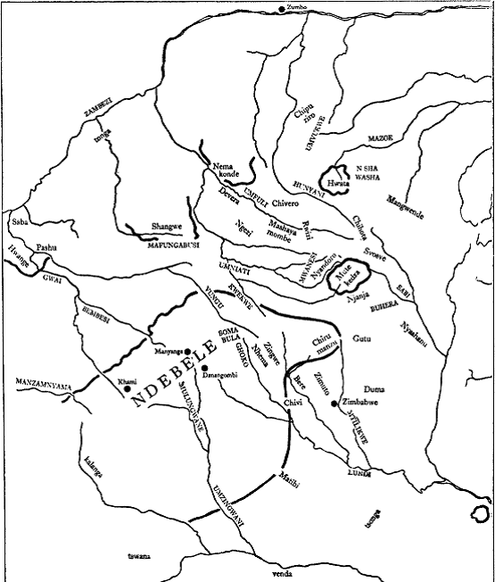 |
| Ndebele State and its Tributaries |
The Ndebele invasion differed from those of the Ngoni in several ways. Firstly, Mzilikazi's people made no attempt to attack the central part of the Changamire state, but settled in the western province of Ndumba, westof the Bembesi river. Secondly, they consolidated their power by exploiting the splits between the Rozvi, and by entering into an economic relationship with them. The main body of Ndebele under Gundwane arrived from the Umzingwani valley in I838-9.15 Ndumba's dynasty vanished from the scene relatively early,16 and the main resistance in the immediate area was led by Mutinhima from the Mulungwane hills. Mutinhima, nicknamed mafuta, was at first successful in his defence, and may not have been pushed out of the hills until after Mzilikazi arrived.17 The Ndebele succession crisis undoubtedly delayed the impact of the Ndebele upon the Shona, but even so it seems to have been surprisingly mild. There are reports of some raids made upon the local people in the first year,18 but tradition from the Kalanga pointed out that although 'they killed a lot of people . . . none of my family were killed. We did not regard the Matabele as bad people. The only thing they fought over was grain.... There was no trouble when the Matabele came'. This was contrasted with the rapacity of the Ngoni during previous invasions.19 On the Manzamnyama river the local Kalanga fled briefly and then returned as tributaries of the new overlords. 20 In short, west of the Bembesi the place of the Ndumba dynasty was simply taken by Mzilikazi and his followers, who settled down among the Kalanga as the Rozvi had done before them. It was thus logical that the Ndebele should not remain on hostile terms with the local Shona because they needed supplies of grain, which would not be forthcoming if raiding was continued for a long time. In I854 Moffat noted the Ndebele prosperity in grain, and in 1858 he confirmed that the Shona were continuing to live inside the Ndebele-settled area in their own villages.21
The Ndebele had thus become rivals of the Rozvi as rulers of the Kalanga and other Shona peoples, and in the period when the Changamire dynasty was weakened by the death of Chirisamhuru, Mzilikazi actually took his place as overlord of certain Rozvi families of the main dynasty. These, including Swabasvi, Lukuluba and Rozani, may have been motivated by internal political jealousies among the Rozvi such as their exclusion from the centre of power and the succession, but they also had an economic motive. The Ngoni invasions had resulted in the loss of a great number of the prized Rozvi cattle, so that there was a considerable shortage.22 The Ndebele, on the other hand, had plenty of cattle but desperately needed more people. The result was that an exchange took place, in which Mzilikazi distributed cattle to the Rozvi mentioned above in return for young people, who were incorporated into the Ndebele state and society.23 This state of affairs extended over the eastern half of the Changamire state and even as far as Tsunga, the land between the upper Umniati river and the Mwanesi range. There, the Nyandoro dynasty had acted as intermediaries between the main Rozvi dynasty and the peoples north-east of them.24 At some time before the great campaigns in that direction in the 1850s and 1860s Ndebele cattle were distributed there as well. 25
It was not likely that this situation would endure for long without serious trouble. Firstly, there was the problem of the main Rozvi dynasty, which had withdrawn into the hills that fringed the Changamire state to the east.26 It was hardly likely to accept the loss of its position without making some attempt to regain it. Secondly, the economic exchange created by the Ndebele was, in the long run, extremely disadvantageous to the Rozvi and other Shona who took part in it. The Ndebele appear to have retained ultimate ownership of the cattle that they distributed, although the milk and limited slaughter rights would presumably have been accorded to the herders, but the young people who were levied by the Ndebele were not allowed to return to their own societies. Moffat noted in 1854 that 'there is nothing they deplore so much as their children being taken from them just at a time when they become useful to their parents', 27 and this practice, taken to excess, could ruin a Shona society. Later the Ndebele did not need to recruit so many from their tributaries, and so caused less damage and created less resentment. But the combination of a serious grievance and the existing organization of the Rozvi state led to the first serious Shona resistance to Ndebele rule.
It is important to stress that the Ndebele did not believe in total war any more than the Shona believed in total peace. During the warfare between the Chirumanzu dynasty and the Ndebele in the 1850s Moffat was able to note that between the fighting in 1854-5 and the surrender of Chirumanzu in I857 there had been no further fighting.28 In August 1866, the Ndebele attempted to trade with Mashayamombe's people, despite their attack on the latter earlier in the year.29 As for the Shona, even the Njanja, whose exploitation of the Wedza ironfield and wide-ranging hoeselling network was one of the great economic success stories of the late eighteenth and nineteenth centuries, and who depended for their sales on good relations with the surrounding peoples, did not hesitate to rob 'Portuguese' zungu traders passing through their territory, even though this hardly endeared them to the peoples who expected to receive the trade goods that the zungu were importing.30
Even when Ndebele raids were major ones, directed against specific targets on the orders of the king, there was a tendency for other people in the area to suffer as well. This was because the Ndebele, whose famed military discipline existed far more in the minds of European writers than it ever did in reality, were prone to scatter across a wide area in search of cattle and women. This emerges clearly from all detailed accounts from
Europeans living among the Shona. Thus, quite unlike Montagu Kerr's fictitious stereotype of a surprise attack on a surrounded village, Mauch, in 1872, gives a picture of a series of raids which continued over a period of about three weeks over a very wide front, from the western Duma on the Mtilikwe-Pokoteke confluence to the upper Pokoteke, an area of some forty miles. The Shona, who had at least three days' warning, suffered various losses but were rarely taken completely by surprise.31 The same picture emerges from accounts of the 1892 raids on the country from Chivi to Gutu and from those of I893 on Zimuto.32 Ndebele raiders also tended to follow up their targets if they fled, as when they pursued people from the Chaminuka medium's base near the Umfuli to the northern Shawasha country beyond the Umwindsi in I883.33 Even Ndebele on a peaceful mission, such as the delivery of a message, would sometimes cover
If the main stimulus behind the great Ndebele campaigns of the 1850s and 1860s was the political threat of the Rozvi dynasty, the economic stimulus of the Shona trade system was also extremely important. Indeed, it appears to have provoked the first important expansion of Ndebele power. In inheriting the Changamire state, the Ndebele had inherited its basic economic framework, which, in spite of a regional emphasis on cattle, was also aligned to the traditional exchange of gold and ivory for cloth and beads. Thus, even during the fighting of 1854-5, the trade system linking the Ndebele with the Zambezi and the coast through the north-eastern Shona country continued to function. Nevertheless, by the 1850s it had become clear to Mzilikazi that the Shona were difficult to dislodge from their mountain strongholds.35 At this point neither side had guns in quantity, although the Shona had been importing a certain number of guns for a very long time.36 The Ndebele had learned from their experiences south of the Limpopo that guns were useful, and in the 1850s and 1860s they did their best to acquire them.37 The basic Kalanga population of the Changamire state had been accustomed to import cloth, and their needs also had to be supplied. Although supplies of both guns and cloth were available through the variously friendly, neutral or hostile Shona dominions to the east, it was obviously desirable for the Ndebele to control the trade routes to a greater extent.
The first expansion of the Ndebele was to the north-west, however. One reason for this was probably that the Ndebele state was too weak in the 1840s to attempt the more hazardous-because more heavily populated and thus better defended-route to the north-east. The badly-watered sand country to the north-west was almost uninhabited and thus offered no resistance to raiders who could easily cross it to strike at the Shona under Hwange, Pashu and Saba on the Deka, Gwai and Zambezi rivers. These people were not only vulnerable but also offered access to one of the trade routes to the sea. This route was along the Zambezi through the Tonga country to Zumbo, Tete, Sena and the sea, and was economically viable in spite of the distance involved because nearly all the distance could be covered by some sort of water transport. Water transport, as Selous noted, made goods from these Portuguese ports much more competitive than those hauled by wagon from the South African ports,38 and in the 1860s 'Portuguese' traders were operating near the Victoria Falls.39 By the early I850s the Ndebele appear to have established their authority over the Zambezian polities,40 especially after the death of the Hwange in 1853,41 although intermittent raids on the area occurred for various reasons as long as the Ndebele state survived.
A Rozvi tradition from the Insiza area suggests that Mzilikazi extended his policy of co-operation with the Rozvi to the point of requesting Chirisamhuru's son Tohwechipi to return from his exile in the direction of the eastern Highlands and settle down in his own country, and that it actually worked for a few years before Tohwechipi broke away.42 It seems certain that the Ndebele tried to get the Mutinhima house to join them, but that they refused. The 1850s saw a rapid revival of the Rozvi power, and as mentioned above they seem to have sunk their differences sufficiently for the Mutinhima group to recognize the paramountcy of Tohwechipi. Even the Swabasvi house broke away from the Ndebele and joined the Mambo's Rozvi.43 But it does not seem that there was a single Rozvi command over the rest of the Shona. Even some of the Rozvi under Lukuluba and Rozani remained under the Ndebele,44 and accounts of the period are full of stories of quarrels and warfare between the Rozvi and rulers such as Hwata, Gutu and the people of the upper Sabi valley.45 Other Shona rulers did attack the Ndebele at the same time as the Rozvi, but it appears to have been on their own initiative.
If the Ndebele exactions of young people provided the basic motive for the Shona resistance to Ndebele rule in the early 1850s, and the revival of the Changamire dynasty gave an example to be followed, the resistance
took a thoroughly traditional form. Shona raiders penetrated deep into the country of the Ndebele, stealing cattle and-according to the Ndebele committing atrocities on women. The most prominent of the raiders were
the Mambo Tohwechipi, his relative Mutinhima, and Chizema the son of the Govera ruler Chirumanzu on the Shashe.46 But these raids provoked an Ndebele response that proved too strong for the Shona. Battles were
fought in the mountains to the east of the Ndebele state: at the Mipopoti range against the Rozvi ruler 'Dlembeu Kupengobuta',47 at Umgulugulu (Guruguru) mountain,48 and against the Mhari ruler Zingwe, who was killed for refusing to supply young people as tribute.49 Tohwechipi was forced to retreat through Chivi past Nyaningwe hill in the direction of Zimbabwe,50 and it may be near there that he won the defensive battle of Chikato. By employing zvitunya-strong people51-who came from the Zambezi to trade and who possessed guns, he was able to defeat the Ndebele some time before 1852, winning himself the name of Chibambamu in the process.52 The fighting continued into 1854, and then there was a lull. But by 1857 the situation had resolved itself in Mzilikazi's favour. The Chirumanzu dynasty surrendered early in 1857,53 and from then until 1889 became a strong ally of the Ndebele.54 Indeed, Chizema, who had been so prominent in raids on the Ndebele, was aided by them in his unsuccessful attempt to win a new land for himself in southern Buhera in the years that followed.55
As for the Rozvi, they suffered from the lack of unity among the Shona peoples. In July 1857 it was noted that 'the rulers holding these lands [goldfields in the central Shona country] were tributary to the emperor Changamire, but today, by a betrayal, the "Uata Mezircase" has taken possession of them from the said Changamire, who lives as a refugee in Njanja, land of the ruler Gambiza, in the district of the Hera, on the edges of his vast domains.' This 'Uata' could have been Mzilikazi, but 'Uata' was also the Portuguese rendering of 'Hwata'. Hwata was the ruler of a comparatively small Hera polity at the head of the Mazoe valley, but if his territory was small his economic influence was considerable. He controlled the goldfields in the northern Shawasha country to the east of him,56 and the locality of the old Portuguese feira of Dambarare.57 This strategic position-probably of importance far back into early Shona history enabled Hwata to dominate much of the trade of the central Shona country, buying ivory and reselling it to the 'Portuguese' traders,58 whose houses were to be found in the upper Mazoe valley.59 Hwata guarded this economic advantage jealously, and when the people near the old feira of Maramuca60-probably the Devera group that owned the Shurushuru goldfield61-attempted to re-open it to 'Portuguese' trade in c. 1830-50, he attacked both them and the 'Portuguese'. He lost the battle but won the war, for the feira was not re-opened.62 Mzilikazi devoted as much effort to the defeat of Hwata as he did to Tohwechipi, and the continued subjection of Hwata to Ndebele rule until I889 suggests that Mzilikazi was fully aware of the economic importance of Hwata's area and intended to profit by it.
There seems to have been a period of peace from 1854 to 1860, but from the latter date to 1873 the Ndebele made what was probably their greatest concerted effort to dominate the Shona. They raided over a wide front from Chivi in the east to Mangwende in the north-east and Hwata in the north, and in the northern areas in particular the relatively few raids mentioned in traditions most probably occurred during this period. Even so, it does not seem likely that the Ndebele were numerous enough to affect all these areas at once, and in one year, I863, when the main strength of the kingdom was turned against the Ngwato to the south-west, the only noted effort to the north-west was a raid by associates of the Ndebele on the Deka river area,63 while another force raided Hwata's associate, Chiweshe, in the upper Mazoe valley.64
The Ndebele effort of 1860 was confined to a small raid to the north-east and another to the south-east. After this, it is possible to make some estimate of the sequence of events in each area affected by the surge of Ndebele activity. In the east, the peoples of Chivi,65 Bere, Zimuto, and the Njanja were attacked in 1861. Bere's Mhari bore the brunt of the attack,66 and were severely weakened in consequence,67 while Chivi's Mhari appear to have succumbed to the power of the newly-imported guns68 and became tributary to the Ndebele. A combination of ambition on the part of Chivi Matsweru's son, Makonese, and the Ndebele expansion led to the deaths of both Chivi and Bere at about this time.69
The attack on the Njanja mentioned above brought the Ndebele back into contact with the Changamire Rozvi, who had arrived in the Hera country-dominated by the two Hera rulers Mutekedza and Nyashanu and
the rapidly-expanding Njanja confederacy under Gambiza-by 1857.70 The Rozvi, led by the Mambo Tohwechipi Chibambamu and his cousins of the Mutinhima house, occupied hills on the frontier between Nyashanu and Gambiza such as Bedza and the Mavangwe range.71 It is stated that the Ndebele made three major attacks in order to rid themselves of the menace of the remnant of Rozvi imperial power, until in 1866 a prolonged siege forced Tohwechipi to surrender.72 He was brought to Mzilikazi but later allowed to leave. Tradition is emphatic that he left Mavangwe and went to Gutu, where he died,73 but in view of the fact that in 1873 Mtikana Mafu led a major force against the Rozvi in Gutu it seems possible that even the defeat of 1866 did not crush Rozvi resistance to the Ndebele.74 In view of the tendency of Ndebele raiders to spread across country it seems likely that most of the damage suffered by the Njanja and the Hera of Mutekedza and Nyashanu occurred at this time. Certainly by 1870 the Ndebele had raided Mutekedza, since they had mutilated his sub-ruler Nyoka.75 This may also be the period of Chizema's attempt to conquer southern Buhera from Nerutanga, which was repulsed by that ruler and the Njanja in spite of his Ndebele backing. The Njanja recall having aided Gutu after this, which may coincide with the I873 raid there.76 The Nhowe of Mangwende remembered in I898 that 'it was in following up the Abarosis that the Matabele first came to know our country, with the result that they commenced killing and raiding through the different districts'.77 The Rozvi were not the only ones responsible, however, because the Ndebele tendency to follow up their enemies applied to Nyandoro of Tsunga as well. Nyandoro had been herding cattle for the Ndebele, but at about this time the murder of an Ndebele nduna led to hostilities,78 and the Ndebele attacked Tsunga, which was flat and nearly indefensible. This was thus one of the very few areas occupied by the Shona that was depopulated by Ndebele action, as the Nyandoro people left en masse in the general direction of their seventeenth-century home in Fungwe. They moved to the nearby Nyoka river, and after a year or two raids pushed them further north-east to the Chirume. A few years later more raids drove them to the Matswitswi caves in Samuriwo's land, from which they fled after Nyandoro's death and further raids as refugees to Mangwende.79 Like the Rozvi, they brought the attention of the Ndebele to those peoples who lived nearby, so that Samuriwo, Chihota, Svosve and Mangwende all suffered.80 But, as the Mangwende people pointed out in 1898, 'The first time they entered the country very few of Mangwende's tribe were killed, and very few were taken prisoners, but they took away with them large numbers of cattle and goats.... The Matabeli never came back into this district again but every year they were raiding the districts on the Sabi river.'80 This marked the farthest point of Ndebele raiding to the north-east.
The pursuit of the Rozvi Mambo and his associate Nyandoro led the Ndebele straight to the north-east up the watershed of the whole country, over open, grassy plains. These were of little significance to their economy except as sources of cattle to replenish their herds, after the lungsickness of 1861 had so reduced them that the kingdom actually contracted in size at this time.82 The route to the north, however, not only led to the trade routes of the heart of the old Mutapa state, but was also of considerable economic importance in itself, running as it did through some of the biggest goldfields still being worked in the early part of the century83 and
across river valleys running west from the watershed, that were full of elephants.84 The great Ndebele efforts of 1860-8 in this area hit the inhabitants very hard. The Ngezi dynasty of Rimuka partly broke up,85 and the Mashayamombe and Chivero people of the Umfuli valley also suffered, so that at one point their rulers were forced to flee to the north.86 However, Mashayamombe at least appears to have returned to his land by 1866, in time to be raided once more. Mzilikazi's attempt to trade for ivory later that year suggests economic motives.87 Economic motives almost certainly also lay behind the very determined efforts made to subject the Hwata trading centre. For four years from 1860-1 the Ndebele attacked, even sending Lotshe to raid Hwata's associate and neighbour Chiweshe at a time when the greatest need for men lay on the Ngwato front to the south-west in 1863. Finally Hwata surrendered in 1864, and was captured to be returned to his home as a tributary ruler.88 However, Hwata, like the Mambo Tohwechipi, appears to have attempted to break away from this relationship, because a major campaign was required in 1868 to subject him again. Even in 1870 his allegiance to the Ndebele was thought to be superficial,89 but he remained at least nominally tributary until 1889.90
After these major campaigns the Ndebele succeeded in making a number of Shona political units tributary to them. This relationship involved the payment of articles of partly symbolic value, such as skins, feathers, hoes, tobacco or spears, or the provision of services, such as labour for hutbuilding.91 Nevertheless, such tribute represented a considerable diversion of valuable man-hours among a people living in a largely subsistence economy. Consequently there was a tendency to break away from Ndebele domination that ran counter to the strong attraction of Ndebele society to many Shona. It was noticeable that in many of the tributary lands farthest from the main Ndebele state the tributary relationship took the form of an alliance between a Shona faction, that relied upon Ndebele support against its rivals within the dynasty, and the Ndebele, who themselves could rely upon this faction. This seems to have been the case with Hwata, Mutekedza and Chirumanzu. The main body of Ndebele tributaries was bounded by a line that ran from the KweKwe river east to Chirumanzu, south to Chivi and then south across the lowveld to Matibi. This boundary varied from year to year, depending upon the political situation in the border areas. Hwange, the Shangwe of the Mafungabusi plateau, Nemakonde, Hwata and Mutekedza were all outlying tributaries, separated from the main body by almost uninhabited land or independent Shona lands.92
The wars of the 1850s established the dominance of the Ndebele in the vicinity of the old Changamire state. The campaigns of the 1860s wiped out the last power of the Rozvi and gave the Ndebele strong economic advantages in the north. In spite of the dissensions of the succession crisis of 1868-72, in terms of relations between the Shona and the Ndebele the latter were, by I873, at the zenith of their power. It is thus ironic, in view of the myths of Ndebele supremacy, to note that their first serious defeat, and the first sign of a change in the balance of power that was to lead in the end to the revolt of many of the Shona tributaries, occurred only six years later, in I879. Ironic, but not surprising. The Shona after all were descendants of the creators of the most impressive Iron Age material culture in southern Africa, the Zimbabwe-Khami culture. They worked what was left of considerable goldfields, and had access to many elephants. Their political institutions and territories were small only by comparison with the few super-states of southern, central and east Africa. By comparison with most polities of that area many Shona rulers held quite big territories. Most of them owned superb defensive sites. Moreover, developments to the south were beginning to aid the Shona. The opening of the Kimberley diamond fields in 1867, the increased availability of guns as Europeans adopted rifles, the expansionist ambitions of Britain and the Afrikaners-and Portuguese counter-moves-all tended to aid the Shona in the short run, though not in the long. Under the circumstances it is surprising that the Ndebele accomplished as much as they did. The sale of gold and ivory and the labour opportunities of Kimberley and the Rand made it possible for the Shona, who in the 1860s had been fatally short of guns by comparison with the Ndebele,93 to re-arm. Guns, which entered the Shona country in the hands of 'Portuguese' traders, Venda mercenaries and gun-runners from the Ndebele kingdom, as well as through Shona long-distance traders and migrant labourers, made the hill strongholds of the Shona almost impregnable even against gun-using Ndebele and Europeans, as the 1896-7 risings were to show.94
In 1879 the missionary Cockin wrote that 'latterly some of the kraals attacked have shewn fight and being many days away and the towns denser, the Amandebele are becoming afraid to go there so much. Cattle and sheep and slaves (are) not coming in so freely now from these distant raids . . .'95 and it is probable that he was referring in particular to the war with Chivi. In the 1860s Chivi was evidently tributary to the Ndebele, but in the reign of Mazorodze, who ruled from 1870 at the latest, the Mhari began to acquire guns from the Venda and to build up a considerable herd of cattle, guarded by a group of men. This represented a threat to Ndebele power in the area, and in October 1879 a major force under Lotshe and Manyewu attacked the Mhari capital of Nyaningwe. Although the Ndebele force consisted of the Mbizo ibuto and probably outnumbered the defenders of Nyaningwe, they were repulsed with the loss of twenty men, their only success being the capture of the Chivi himself on an outlying hill. The loss of twenty men was not significant in itself, but the defeat was, and even the execution of Chivi did not hide the fact that although the Ndebele could operate over the open ground, they could not take the hill-strongholds of the Mhari, who were henceforth independent.96
The year 1880 saw the defeat of the Gaza by Gutu in the similar battle of Rasa mountain,97 and the beginning of a rift between the Ndebele and their ally the Chaminuka medium of the upper Umfuli. Up to then, Lobengula had paid the medium tribute in return for religious services,98 and in that year they combined to raid the Shona north of the Hunyani. But at the same time the Chaminuka medium claimed that he, and not Lobengula, had the power to grant hunting-rights to Europeans in the area, and his son Jugu 'had said that his father would now show Lobengula that the country beyond the Umniati river belonged to him, Chameluga' and that if necessary he could drive away the Europeans by his magic. It is therefore not surprising to find that in 1883 Lobengula had the Chaminuka medium killed. His men raided as far as the Shawasha country of Chinamhora, 99 whose people had taken Chaminuka's cattle,100 which in all probability had been taken from them in 1880.
In 1882 Selous noted that Ndebele had reached the Mukwadzi river west of the Umvukwe range,100 and in 1887 there was a major raid on the Umvukwe area,102 probably the one led by Gwasagwasa against the Shona ruler Chipuriro, far to the north.103 This may have represented a revival of the policy of the 1860s of gaining control of the trade routes to the Zambezi, for beyond Chipuriro lay the prazos of Matakenya, Jose de Araujo Lobo, who had earlier been in contact with the Ndebele, buying their ivory. In 1888 a major raid struck at the Mashayamombe and Rwizi people of the Umfuli valley.104 The reason for this is not known. The attack on Rwizi may have been to prevent a renewal of the Chaminuka cult, while the fact that a very large number of people were removed from Mashayamombe's may mean that this was the raid, recalled in tradition, that resulted from a civil war among Mashayamombe's people in which one side called in the Ndebele.105 But it may also have resulted from the fact that the Shona were undeniably growing stronger. Isolated Ndebele were liable to be killed if they were discovered. In 1887 a whole party of Ndebele was killed, and indeed the 1888 raid 'suffered so severely that Lobengula was very angry and another one was sent out in another direction.' Montagu Kerr, with his preconceived ideas, was amazed to hear the Shona at the head of the Mazoe valley in 1884 coolly discussing their chances of success, with some hope of victory, but it seems that in the 1880s the Shona were indeed beginning to turn the tide of Ndebele power.106
This trend was greatly advanced by the Portuguese, who, seeking to counter British expansion by limiting the power of the Ndebele upon which Rhodes's claims were based, sent two expeditions into the Shona country in 1889. Nominally led by Vitor Cordon and Paiva de Andrada, but actually relying upon the forces of such prazo-holders as 'Kuvheya', Manoel Antonio de Sousa, and 'Chimbango', Vicente Jose Ribeiro, they reached Nemakonde and Mangwende respectively, and made treaties with Shona rulers in a wide belt across the country from the Mafungabusi plateau to the upper Sabi. Portuguese flags were distributed in acts of vassalage that were not taken seriously by the Shona, and large numbers of guns were handed over by the Portuguese.107 The effect of the treaties was to give nearly every Shona polity north of the Umniati river a considerable increase in the size of its armoury. The 'Portuguese' zungu expedition to the whole Charumbira-Mapanzure-Bere group of peoples in 1872 had only had forty-eight guns for sale,108 but the 1889 expeditions gave this many to a single ruler. Even the small polities received ten guns, and powder and ammunition were supplied as well.109 This was a huge increase in Shona fighting strength, and from both oral traditions and some of Cordon's treaties110 there is no doubt that the whole tenor of this major political development was anti-Ndebele. The implications of this in Shona history proper cannot be discussed here, but the effect on the balance of power between the Ndebele and the Shona was immense. Hwata, Nemakonde, Mutekedza and some of the Shangwe all abandoned their allegiance to Lobengula and accepted the Portuguese guns and flags which were to be found as far south as the Njanja country and beyond.111 No major raiding forces of Ndebele ever entered the central Shona country again. There are strong suggestions that the revolt against Ndebele power even extended as far south as Gutu, where from 1889 the rulers no longer had the Gaza state to balance against the Ndebele, and to Chirumanzu, where the death of Bangure allowed his brother Chatikobo, aided by some Rozvi, to lead the people into their first revolt since 1857.112 But the arrival of the British in 1890 altered the situation.
Although there can be no doubt that Lobengula was thoroughly opposed to the arrival of Rhodes's men on his eastern frontier, he remained functionally neutral to the extent that he did not attack the Pioneer column, and once the British had driven away the Portuguese and captured the formidable Sousa, he took advantage of the British presence to regain control over Nemakonde and Chirumanzu, although Hwata and Mutekedza remained lost to him. Even so, this was only possible with the co-operation of Shona interest groups. In a coup d'etat in 189I, Chinyama, son of Bangure, drove out his uncle Chatikobo and became the new Chirumanzu with Ndebele aid.113 At the end of the year an Ndebele force visited the Nemakonde area and, after consultation with the most important spirit medium, killed Nemakonde Hodza and four others in an action that has all the marks of a coup d'etat by an internal group.114 During 1892 a similar split in the Gutu dynasty and an appeal for Ndebele help by Makuvaza led to a joint Chirumanzu-Ndebele force installing him as ruler;115 at this time a small party of Ndebele even reached the highlands across the Sabi, perhaps the furthest point ever attained in that direction, in this last rather feeble demonstration of Ndebele power.116
It is beyond the scope of this paper to discuss the events and negotiations that led to the war in 1893 that broke the Ndebele state, except insofar as they concern the Shona. The lowveld area had been subjected to raiding for years, partly at least by unofficial raiding parties, causing Matibi to move away from his northern lands into the remote lowveld in the late 1880s.117 But the decisive area was around Chivi and Zimuto. Chivi was raided in late 1891, to the delight of Rhodes, who was trying to prove Lobengula's dominance of the area,118 but in July and August 1892 a major raid on the recalcitrant Chivi and Zimuto led to an appeal by Chivi to Rhodes's deputy Jameson.119 This in turn led to a demand that Ndebele raiders stay away from the town of Victoria and the main road,120 a demand that was fully complied with, as far as the Ndebele ruler was concerned, until the crucial raid of July 1893.121 Even this raid came about partly as a result of Shona actions. Early in June 1893 a joint party of raiders from Bere and the Makamure house of Zimuto stole cattle from Mpakame, a Shona tributary of the Ndebele at Guruguru hill. Mpakame complained to his overlord the Ndebele-ized Rozvi Lukuluba at the Ghoko range. Lukuluba raided Bere in retaliation, but on being turned back by Company police, reported in turn to his superior, Mgandane of Nxa.122 This led directly to the famous raid in July on Bere and Zimuto near Victoria, to the fight of 18 July and to Rhodes's decision to overthrow the Ndebele kingdom.
Even before the British columns set out, however, Shona raiders were moving in to take Ndebele cattle.123 As the Victoria column began to move towards its rendezvous in the north with the Salisbury column, it was joined by large forces of Shona. Zimuto sent 120, Madziviri 50, and Gutu abandoned the Ndebele who had put him in power the previous year and sent eighty men. As the force approached Chirumanzu its ruler Chinyama followed Gutu's example and offered 300 men.l24 A few days later Chivi's men marched through Victoria to catch up with the advancing columns.125 These Shona, acting in concert for the first time in their particular histories, fought at the Shangani battle with some success, considering that they were left outside the defensive laagers.126 Meanwhile in the south, Matibi, whose relations with the Ndebele had been deteriorating to the point of outright war as he was repeatedly raided, experienced a further raid in late 1893 and retaliated in force, together with the police. They penetrated deep into Godhlwayo.127 These Anglo-Shona alliances of 1893 had a profound effect on the subsequent history of the southern Shona, especially in 1896. As the Ndebele state fell, Shona raiders from all over the southern Shona country and from as far as the upper Sabi valley began to move towards the Ndebele herds, and the end of Ndebele power in the summer of 1893-4, saw Shona raiders striking deep into the Ndebele kingdom, as they had done in the early 1850s.128
SUMMARY
For a variety of reasons the extent, number and severity of Ndebele raids upon the Shona-speaking peoples have been greatly exaggerated in the past. Moreover most studies of the Ndebele have failed to take into account the fact that the Ndebele conquered an already well-established Shona state with an economy linked with the Indian Ocean trade. This article seeks to show that the bulk of Ndebele raiding before 1873 was a response to both the political and military threat of the Changamire Rozvi dynasty and to the economic needs of the state that had been taken over. Even so, Ndebele raids were limited in extent and duration, and the two decades after 1873 saw a steady revival of Shona strength. In spite of Ndebele raids aimed at preventing this process, the independent Shona strengthened themselves by re-arming and 'alliances', and were able to take part in the eventual overthrow of the Ndebele kingdom.
This article is a condensed version of a paper presented at the History Workshop,
Gaborone, September 1973.
Notes
- Sources with biases, conscious or unconscious, include: The Matabele Journals of Robert Moffat, 1829-I860, ed. J. P. R. Wallis (London, 1945); The Matabele Mission ...of John and Emily Moffat, I858-I878, ed. J. P. R. Wallis (London, I945); W. Montagu Kerr, The Far Interior (London, I887); Gold and the Gospel in Mashonaland 1888, eds. C. E. Fripp and V. W. Hiller (London, 1949); The Northern Goldfields Diaries of Thomas Baines, ed. J. P. R. Wallis (London, 1946); J. Mackenzie, Ten Years North of the Orange River (Edinburgh, I871); F. Coillard, On the Threshold of Central Africa (London, I897) A. A. Anderson, Twenty-five Years in a Waggon (London, I888); The Southern African Diaries of Thomas Leask I865-I870, ed. J. P. R. Wallis (London, 1954).
- 'I hope they do raid the Barotses', wrote the Company's secretary in I892. 'All these raids and deaths and murders ought to be entered into a book, so that we may always be able to prove justification and their being a cruel damnable race.' Hist. MSS CO 4/I/I F. Rutherfoord Harris to J. W. Colenbrander, 9 Feb. I892. Unless otherwise stated all reference codes relate to the National Archives of Rhodesia, Salisbury.
- T. O. Ranger, 'The rewriting of African History during the Scramble: the Matabele dominance in Mashonaland', Afr. Soc. Res. iv (I967); D. N. Beach, 'The Adendorff Trek in Shona History', S.A.H.J. III (197I).
- T. N. Huffman, The Leopards Kopje Tradition (in press).
- This interpretation, which differs radically from that generally made previously, was made independently by Dr Mudenge (S. I. Mudenge, 'The Rozvi Empire and the Feira of Zumbo', unpubl. Ph.D. thesis (London, 1972), 35-43, 54-70) and myself (D. N. Beach, 'Historians and the Shona Empires, II, 3, The Changamire Problem', Univ. of Rhodesia, Hist. Dept., Henderson Seminar Paper, 20, 1972), but to Dr Mudenge belongs the credit for convincingly identifying the Khami culture in its earlier phase with the Torwa dynasty.
- T. N. Huffman, 'The Rise and Fall of Zimbabwe', J. Afr. Hist. XIII, 3 (I972), 356-7.
- G. Fortune, 'A Rozvi text with translation and notes', NADA, 33 (1956).
- Mudenge, 'The Rozvi Empire', 52, 70, 159-60; N. Sutherland-Harris, 'Trade and the Rozvi Mambo', in J. R. Gray and D. Birmingham, eds., Precolonial African Trade (London, 1970).
- F.W.T. . Posselt, Mambo and his Court (Salisbury, 1923), 2; N. 3/33/8, J. W. Posselt, N. C. Charter to Acting C. N. C. Salisbury, c. I Jan. 1904; Mudenge, 'The Rozvi Empire', 187-91. Dr Mudenge's use of Portuguese documents to date Rozvi reigns in the late eighteenth century is one of the most important breakthroughs in the study of Rozvi history. His explanation of the origins of the Jiri-Gumunyu dispute is another, and his argument has influenced my use of the evidence cited below.
- K. R. Robinson, Khami Ruins (Cambridge, 1959), Appendix 6, Tradition 2. This is a reflection of a tradition recorded in one of a set of very valuable traditions collected in 1898-1906 (NB 6/i/i, N 3/33/8 and A 3/I8/I8): A 3/18/28 C. T. Stuart, N. C. Gwelo to C. N. C. Bulawayo, 16 Feb. 1906. This is not the Ndumba after whom the Ndumba hills at the Bubi source are named, A 3/18/28 R. Lanning. N. C. Inyati to C. N. C. Bulawayo, 21 Apr. 1906.
- The main traditions of Rozvi politics are found in J. W. Posselt in N. 3/33/8; F. W.T. Posselt, Mambo; M. V. J. Rukara, in Hist. MSS Msc. RU 4/I/I; A. Marwodzi, 'The Barozwi', NADA, 2 (1924); E. M. Lloyd and S. Muhlanga, 'Mbava', NADA, 3 (I925) and 'Mbava and the others', NADA, 4 (1926); Fortune, 'A Rozvi text'; K. R. Robinson, 'A History of the Bikita District', NADA, 34 (1957); S. Rhodesia Ministry of Internal Affairs Delineation Reports, Bikita and Buhera, I964-5. The simplest and most convincing explanation of the dispute is that the modern Jiri group are descended from Mutinhima, son of Gumboremvura, and that the Gumunyu group are descended from Chirisamhuru. The co-operation of the Mutinhima house with the main house in the 1850s is described below. The death of Mambo Tohwechipi Chibambamu in c. 1873 after his defeat in i866 led to the political eclipse of his house and the rise of Mutinhima's. The earliest known reference to Tohwechipi's son or brother Chikore makes it clear that he was not regarded as Mambo-although the reference must be regarded with caution on this point because it comes from a traditionally pro-Mutinhima area (A 3/I8/28, F. G. Elliott, N. C. Selukwe to C. N. C. Bulawayo, I9 May I906). By I890 the people near Zimbabwe stated that 'Tihina' (Mutinhima) was ruling the Bikita Rozvi (Argief van die N. G. Kerk, Cape Town, Report of S. P. Helm, I89I). In I896 the Gumunyu-descended Chiduku group joined the ritual-position holder Mavudzi and the Mbava group in the installation of a Mutinhima-house member, Chikohore Chingombe, as Rozvi Mambo in the Mavangwe hills, Buhera (N i/i/8, N. C. Ndanga to C. N. C. Salisbury, 2 Mar. I897). Subsequently the Mutinhima house dominated the Buhera and Bikita Rozvi until the revival of the Chirisamhuru-Gumunyu house in Bikita in the I950s.
- F. W. T. Posselt, Mambo, 6; Sr Mary Aquina, O.P., 'The tribes in Chilimanzi Reserve and their relation to the Rozvi', NADA, IX, 2 (1965), 4I; Fortune, 'A Rozvi text', 72; A 3/18/28 T. M. Thomas, Acting N. C. Insiza to C. N. C. Bulawayo, 16 May 1906; MIA Delineation Report, Que Que, I963; Stuart in A 3/1i8/28; NB 6/i/i S. N. G. Jackson, N. C. Belingwe to C. N. C. Bulawayo, 31 Mar. 1898.
- G. J. Liesegang, 'Nguni migrations between Delagoa Bay and the Zambezi, I821-I839', Afr. Hist. Studies, III, 2 (1970); W. A. Elliott, 'The Ma-Shuna' in D. Carnegie, Among the Matabele (London, I894), II3; F. G. Elliott in A 3/I8/28; S. N. G. Jackson in NB 6/i/i; Hist. MSS WE 3/2/4; Hist. MSS Wi 8/i/i Nkani I passim.
- Robert Moffat, J7ournals, I, 369; F. G. Elliott A 2.I8/28. In this case the Mutinhima faction admitted their subordination to Chirisamhuru's house.
- Hist. MSS Wi 8/I/2 Ntabeni I-2.
- Stuart in A 3/I8/28.
- Hist. MSS Wi 8/i/i Ngungu 2; T. M. Thomas, Eleven Years in Central South Africa (London, i873), I65; S. N. G. Jackson in NB 6/i/i; 'Mziki' (pseudonym of A. A. Campbell), 'Mlimo (Pietermaritzburg, I926), 85. This latter account, which existed in draft form in I905 and in final form in I9II, has been described as a fabrication. But the presence of information about Lukuluba and Chizema in particular, and about the affairs of the eastern Ndebele in general, suggests that it is indeed a body of genuine tradition collected in Insiza I897-I905 and added to a fictional romantic story.
- Hist. MSS Wi 8/I/2 Ntabeni 4.
- Hist. MSS Wi 8/i/iI Nkani I-2.
- G. A. Taylor, 'The Matabele Headring', NADA, 3 (1925), 4I.
- Robert Moffat, Yournals, I, 2I4-I5, 224, 265; II, I58.
- F. G. Elliott in A 3/I8/28.
- F. W. T. Posselt, Mambo, 6; Stuart in A 3/I8/28; Lloyd and Muhlanga, 'Mbava and others', 92.
- N 3/33/8 E. Morris, N. C. Marandellas to Acting C. N. C. Salisbury, I Jan. 1904.
- W. Edwards, 'The Wanoe', NADA, 4 (I926), I8. Edwards gives Nyandoro's Fungwe origins correctly (Morris, in N 3/33/8), but omits the period in which he ruled Tsunga under the Rozvi.
- Robert Moffat, Journals, I, 233, 240, 369. Moffat originally used the term 'Shona' to mean, principally, 'Rozvi', and 'Bamakalaka' to mean 'Kalanga'.
- Ibid., I, 319.
- Ibid., II, 59.
- Leask, Diaries, 81, 88.
- The Journal of Carl Matuch I869-I872, ed. E. E. Burke (Salisbury, 1969), 222.
- Ibid., 209-214.
- E.g. A i/o/i, H. Paulet to L. S. Jameson, 28 July I892.
- F. C. Selous, Travel and Adventure in South East Africa (London, I893), II6.
- Baines, Diaries, I, I63.
- Robert Moffat, Journals, I, 224, 234, 241, 250, 36I; II ,79-80, 104.
- Mudenge, 'The Rozvi Empire', 117-I8. Zumbo sent two guns every three years.
- Robert Moffat, Yournals, I, 234; II, 79, 104; John Moffat, Matabele Mission, I 52, i6 i.
- Selous, Adventure, 474.
- Baines, Diaries, II, 469.
- Robert Moffat, Yournals, I 243.
- E. C. Tabler, The Far Interior (Cape Town, 1955), 212.
- T. M. Thomas in A 3/i8/28.
- F. G. Elliott and Stuart in A 3/i8/28; F. W. T. Posselt, Mambo, 6.
- Stuart and T. M. Thomas in A 3/i8/28; M\IA Delineation Reports, Que Que and Gatooma, 1963-5.
- D. J. van der Merwe, 'Some history of the Vakaranga in the Gutu Reserve', NADA, I4 (1936-7), 73. The episode described immediately preceded the Jiri Rozvi move to Bikita in the late nineteenth century; Marwodzi, 'The Barozwi', go. By 'this country of the Batonga' he meant the upper Sabi valley; for Hwata, see below.
- Robert Moffat, Journals, 1, 233, 24I, 250, 368-9; Campbell, 'Mlimo, 103.
- S. N. G. Jackson in NB 6/i/i.
- Leask, Diaries, 114.
- NB 6/i/i W. T. T. Driver, N. C. Selukwe to C. N. C. Bulawayo, 3I Mar. I898; I am indebted to Mr R. G. Mwanza for his tradition confirming and explaining Zingwe's death.
- S. A. Dornan, 'Rhodesian Ruins and Native Tradition', S.A.J. Science, xii, 2 (I9I6), 508.
- I am indebted to Mr A. Samasuwo for his translation of this Rozvi dialect word.
- Rukara in Hist. MSS Misc/RU 4/I/I; MIA Delineation Report, Bikita, I964; Robert Moffat, Journals, I, 369; J. Chapman, Travels in the Interior of South Africa 1849-1863 (Cape Town, i868), I, 63. I am indebted to Mr J. D. Cobbing for this latter reference.
- Robert Moffat, Journals, II, 59.
- D. N. Beach, 'The Rising in South-western Mashonaland, 1896-7', unpubl. Ph.D. thesis (London, I971), 205.
- Univ. of Rhodesia, Hist. Dept., Text 78 Bha; MIA Delineation Report, Buhera, 1965.
- Izidoro Correia Pereira, 'Mappa das minas conhecidas na distrito de Senna', 31 July I857, in Memoria e Documentos acerca dos Direitos de Portugal aos territorios de Machona e Nyassa I890 (Lisbon, I890), 296. 'Mezircase' could be a variant of the Hwata praisename mufakose.
- P. S. Garlake, 'Excavations at the Seventeenth-century Portuguese site of Dambarare, Rhodesia', Proc. Trans. Rhod. Scientific Assn. LIV, I (I969).
- Mauch, Journal, 220; P(ublic) R(ecord) O(ffice), London, CO 417(I4) South Africa 1887, II, Mandy to Jones, 8 Feb. I887, 46. I am indebted to Dr N. M. B. Bhebe for this reference, and for having drawn my attention to the importance of Hwata's trade system.
- Hist. MSS 6/z/1 29 Dec. I890.
- P. S. Garlake, 'Seventeenth-century Portuguese earthworks in Rhodesia', S.A. Archael. Bull. xxi, 84 (I966).
- Pereira, 'Mappa das minas', 296.
- Baines, Journals, II, 472-5.
- Chapman, Travels ii, 161.
- Campbell, 'Mlimo, 139.
- John Moffat, Matabele Mission, 136-7, 152; T. M. Thomas, Eleven Years, 3I4. I am indebted to Mr J. D. White for his help on this point.
- Campbell, 'Mlimo, 137.
- Mauch, Journal, 176-8.
- John Moffat, Matabele Mission, 152.
- Beach, 'Adendorff', 38-9; Driver in NB 6/i/i.
- Pereira, 'Mappa das minas', 296.
- MIA Delineation Report, Bikita, I964; Fortune, 'A Rozvi text', 73.
- Leask, Diaries, IO2; T. M. Thomas, Eleven Years, 339-40.
- MIA Delineation Report, Bikita, I964.
- Driver in NB 6/i/i; C. G. Oates, Matabeleland and the Victoria Falls (London, 1881), 59; Campbell, 'Mlimo, I5I; Hist. MSS Wi 8/i/2 Ntabeni 53.
- Baines, Diaries, II, 413.
- See 57.
- N 3/33/8, W. Edwards, N. C. Mrewa to Acting C. N. C. Salisbury, ii Dec. I903, encl. 'A Short History of Mangwendi's People, I3 Apr. I898'.
- Edwards, 'Wanoe', i8.
- Morris, in N 3/33/8.
- Morris and Edwards in N 3/33/8.
- Edwards in N 3/33/8.
- Leask, 74, 221.
- Pereira, 'Mappa das minas', 296.
- Large-scale ivory shooting by European hunters in these valleys began in 1865 (Tabler, Far Interior, 27I), and by I884 African gunmen had decimated the game there (Kerr, The Far Interior, I, 44).
- N 3/33/8 S. N. G. Jackson, N. C. Hartley to Acting C. N. C. Salisbury, c. 1 Jan. 1904; PRO, FO I79/279 No. 57, 'Memorandum on the Rights of Portugal in the territories to the south of the Zambezi, communicated by M. de Freitas,' I2 July 1890; Baines, Diaries, 1I, 498.
- S. N. G. Jackson in N 3/33/8.
- Leask, Diaries, 86.
- Baines, Diaries, II, 498. T. M. Thomas (Eleven Years, 325) incorrectly made the date 1863, but Baines was closer to the event in time and place, as well as being backed up by John Moffat.
- Baines, Diaries, I, XXXVII, 55, 498; Selous, Adventure, 47, 295.
- Mandy, in PRO, CO 417(14) South Africa I887, II.
- On tribute, see Beach, 'Rising', 126, and N. M. B. Bhebe, 'Christian Missions in Matabeleland, 1859-1923', unpubl. Ph.D. thesis (London, 1972).
- Beach, 'Rising', 124-35.
- John Moffat, Matabele Mission, 152; Leask, Diaries, 69, I90.
- Beach, 'Rising', 143-9.
- Hist. MSS LO 6/I/4, J. Cockin to Mullen, May I879.
- Beach, 'Adendorff', 39-40; the I877 date for the war given in my earlier articles has been revised by Hist. MSS TH 2/I/I, for which reference I am indebted to Mr J. D. Cobbing.
- N 9/I/6, Statistical Report for year ending 31 Mar. 1900, Gutu.
- Beach, 'Rising', 155-7.
- Selous, Adventure, 113-I6, 465-6.
- J. Chidziva, 'History of the vaShawasha', NADA, ix, i (I964), 29.
- Selous, Adventure, 50-3.
- Fripp and Hiller, Gold and the Gospel, 32, 34.
- Driver in NB 6/i/i; Hist. MSS, Wi 8/i/2, Ntabeni 53-5. Gwasagwasa also visited Chipuriro in I892 (A i/9/i, Lendy to Jameson, i Apr. I893), probably to investigate the removal of Chipuriro by the Portuguese (L. Decle, Three Years in Savage Africa [London, I898], 2I7).
- Fripp and Hiller, Gold and the Gospel, 27-30, 51, 69; Decle, Three Years, 141.
- D. N. Beach, 'Kaguvi and Fort Mhondoro', Rhodesiana, 27 (1972), 38 n.
- Fripp and Hiller, Gold and the Gospel, 27-8, 3I, 65, 67; Kerr, Far Interior, i, 64, 151.
- Memoria e Documentos, 27-8, 268-76, 333; Boletim Oficial... de Mofambique, 51, 2I Dec. I889, 725; B.O.M. I2, Mar. I890, I52; B.O.M. 20, 17 May I890, Caetano de Carvalho Montez, 'Documentos para a historia de Mozambique', Mojambique, documentatio trimestral, 25, I94I, 86, 98-iii; J. C. Paiva de Andrada to Minister of Marine, 18 Aug. I889, Arquivo do Ministerio dos Negocios Estrangeiros, Lisbon, Soberania de Portugal na Zambezia, Caixa 2, I889; J. C. Paiva de Andrada to Francisco Costa, 15 and 27 Dec. I889, Arquivo Hist6rico Ultramarino, Lisbon, Mo4ambique, 2a. Repartiio, 6a. Caixa I889; Freitas, op. cit.; Beach, 'Rising', I74-97.
- Mauch, Journal, 213.
- CT i/i16, C. Lendy to A. R. Colquhoun, 18 Dec. 1890.
- Memoria e Documentos, 27i-6; University of Rhodesia, Hist. Dept. Texts 53-4, 6o-i Hty.
- CT I/I2/8, A. R. Colquhoun to F. Rutherfoord Harris, io Dec. I890; CT I/5/2, R. G. Nicholson to F. Rutherfoord Harris, 7 Nov. I890.
- LO 5/2/3, Lt.-Col. Pennefather to F. Rutherfoord Harris, 4 Sept. 1890; URHD Text 26 Czi; N 9/4/I3, N. C. Chilimanzi to C. N. C., I Nov. 1902.
- URHD Text 26 Czi; Hist. MSS WI 5/I/I, 7 Apr. I897.
- A 2/8/I, L. S. Jameson to Acting Secy. BSAC Cape Town, 2 Dec. I89I.
- DV 5/I/I, Chaplin to L. S. Jameson, 25 Mar. I892; CT I/I5/2, L. S. Jameson to Acting Secy. BSAC Cape Town, I5 July I892; A I/9/I, telegraphic conversation A. 19 Aug.-Sept. I892; NB I/I/9, A. N. C. Gutu to C. N. C., 9 Sept. 1900.
- Houghton Library, Harvard, Diary of W. L. Thompson, 29-3I Aug. I892. I am indebted to Dr J. K. Rennie for this reference.
- Hist. MSS BE 2/I/I, Diary of Tshakoma mission, 1st quarter, 1887.
- Beach, 'Adendorff', 40, 43.
- LO 5/2/2I, F. R. Harris to London Board of BSAC, 27 July I892.
- A 2/1/4, H. M. Hole to J. W. Colenbrander, 5 Sept. I892.
- Beach, 'Rising', 230-5.
- E. G. Howman and J. H. Stanley Adam, 'The hand of glory', NADA, 6 (1928), 33-4; Campbell, 'Mlimo, -I; CT 1/14/I, C. Lendy to L. S. Jameson, 18 June 1893.
- Hist. MSS CO 4/I/I, B. Dawson to J. W. Colenbrander, 24 Sept. I893.
- Hist. MSS MO 14/2/I, 8 and io Oct. I893; Hist. MSS WE 3/2/3; Hist. MSS WI 9/2/4, 16 Oct. 1893.
- CT 1/14/2, F. R. Harris to H. Loch, 28 Oct. I893.
- W. A. Wills and L. T. Collingridge, The Downfall of Lobengula (London, 1894), 107.
- DV i/i/i, Hay and Crowne to F. R. Harris, 7 Mar. I894; DV 7/2/2, trial of H. D. Hay, 14 Dec. I893; L 2/3/8, Vigers to Duncan, 7 Dec. 1893.
- N I/1/3, N. C. Hartley to C. N. C., I9 Feb. and I5 July I895; N I/I/2, N. C. Charter to C. N. C., 30 Jan. and I9 Feb. I895; N I/I/I2, N. C. Victoria to C. N. C., 2 and 16 Oct. I894; A IS/I/I, N. C. Victoria's report to 10 Dec. I894.
Subscribe to:
Posts (Atom)


